

Full-day country walks in
SE England and beyond
Ashdown Forest
Distance: 14 miles.
Time without long breaks: Apx 7 1/2 hours.
Terrain: Generally easy but uneven going in places.
How to get there and back: Train to Tunbridge Wells and then a no 291 bus from opposite the station to Withyham (get off at the Dorset Arms pub). Catch the same bus from Hartfield back to Tunbridge Wells. Buses run hourly and the last one back is around 6.30pm, but check here for times.
Pub breaks: There are no pubs, shops or cafes – so bring your own. Hartfield, at the end of the walk, has The Anchor and the Wagon & Horses.
More information: An alternative to going via Tunbridge Wells is to go via East Grinstead, which is on the same bus route. As there is very little shelter and no pubs, the walk is best avoided in rainy weather. Since 2005, the forest has been used for communal grazing in the summer months, so watch out for cows, sheep and ponies, as well as deer.

Click on the image below to access
the full map on plotaroute

Ashdown Forest is one of the largest free areas of open public space in southern England. A designated Site of Special Scientific Interest, it is home to a great variety of flora and fauna. It is probably best known, however, as the playground of Winnie-the-Pooh and this walk takes in a number of sites mentioned in the books, including Pooh bridge. Starting in Withyham on the Kent/East Sussex border, the route also includes a war pilot's memorial, a nature reserve and a restored windmill. It ends at the village of Hartfield, which has two pubs. The walk can be combined with a visit to Tunbridge Wells in the evening, which has a good selection of pubs and restaurants and a great intimate music venue, The Forum.
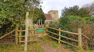
From the bus stop, cross over the road to the pavement and walk up past the pub and the houses. When the pavement ends, cross over and take the steps up to a gate following the footpath sign. Cut across the field to reach Withyham church, which contains a chapel for the Sackville Family, the Earls of De La War, who own Buckhust Park and a lot of the local land. The original building was partially destroyed when it was struck by lightning in the 17th century. Head past the church and across the churchyard and exit from the other side. You will see pond on your right. Follow the lane past the vicarage and an old house. Then keep along the lane, which initially has a wooden fence alongside it.

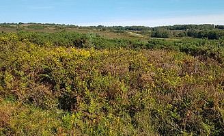
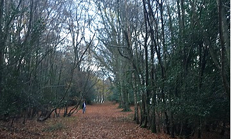
This is Five Hundred Acre Wood, which was renamed Hundred Acre Wood by A.A Milne in his children's books and is the fictional home to Winnie-the-Pooh and friends. Keep on this track, looking out for the waymaker posts for the Wealdway. When it swings left, take the path straight ahead through a wooden gate. Stick to this path until you eventually take a right-hand fork at a post to exit the woods. Here the landscape changes from beech trees to gorse, bracken and heather. Ashdown Forest largely consists of this sandy heathland, although it was once covered by trees. The deforestation is attributed to charcoal burning when the Weald was the centre of the iron industry in the middle ages.

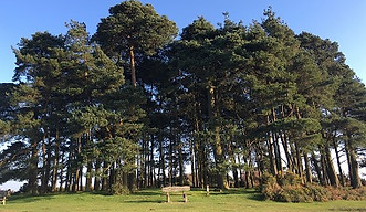
Turn right along the road and walk up to the junction. Here you will find Kings Standing, a tree clump and local landmark with ancient pillow mounds. Return to the Kings Standing car park and cross the road, going through a gate opposite. Go straight ahead until you reach a broad track, running parallel to the road. Turn left. You are now back on the Wealdway. On the other side of the road is the site of the Kings Standing communications station, which was used to transmit radio broadcasts during World War II. The track runs south towards another tree clump at Camp Hill. Here you will find a triangulation point and impressive views of the surrounding landscape. This is an ideal spot to take a break.

On leaving here, continue down the track to the bottom of the valley and then turn right across a small wooden bridge over a stream. Ignore the large firebreak track on the right and instead continue past the gorse bushes to the next clearing on the right. Head north up the hill, taking the path that runs along the edge of a fence and a wooded area, with views of the South Downs behind you. After just over half a mile, you will come to a wooden gate on the left. Go through the gate, crossing over a tarmac track and follow the path round past a house until it meets a road. Cross the road and take the lane straight ahead to Nutley Windmill, a beautifully restored post mill. This is another good place for a rest.
Keep walking up past the paddocks until you reach a kissing gate which leads on to a driveway. Turn right. After the trees end, you will come to Old Lodge Nature Reserve on the left and a small wooden gate. You may need to climb over it if it is padlocked (alternatively, you can just carry on along the drive and access the reserve further down if you want to). Turn right through a gateway, initially walking parallel to the lane in the same direction. The track soon bears left. Follow it round until it meets the track running north to south, then turn right. Go up some steps to exit the reserve via a gate. With the car park to your left, take the path on the right, then cut across the field following a path to another car park.
Follow the track down, until it eventually enters some woods. Then cross over the lane at Chuck Hatch and take the path opposite, following the sign to Pooh Bridge. This long, winding footpath takes you deep into the woods until you eventually come to the bridge itself, where playing 'pooh sticks' is obligatory (don't be fooled, incidentally – there is another smaller wooden bridge just before it!). On the other side of Pooh Bridge, the path ascends up through the woods before joining a lane. On the right is the turning for Cotchford Farm (see panel below). Just past this, take the footpath on the right through a small wooden gate.

You are walking through the grounds of the Buckhurst Estate and following the Wealdway long distance footpath. After a mile along, you reach Fisher's Gate and some cottages. At the gate to the main house, go over the stile on your left, following the footpath down and over a bridge and then going over another stile to reach a junction of tracks. Go straight ahead following the sign for the Wealdway (often simply marked 'W/W'), then turn right to go past a house. Keep going straight ahead, passing Kovac Lodge and a fishing lake. At the entrance, take the track rather than the driveway. When you reach a large metal gate to the fields on your right, turn left into the woods following the broad track.
Turn left and follow the track. If you turn to look behind you, you can see distant views of the North Downs. After another track merges from the left, the route runs parallel to the course of a Roman Road. Keep on the Wealdway. It runs between lines of trees and bears right before reaching Greenwood Gate clump. Carry on along the track. Just after the trees on the left end, take the clearly marked winding footpath on the left, with a car park visible. This path emerges at a grassy track. Turn right here and head down the track. When you reach two trees that are immediately ahead, take the footpath on the left which leads to a road.
From Camp Hill, you leave the Wealdway and instead carry on along the track in the same direction as before, heading south-west. The track leads to Ellison's Pond and Crowborough Road. Cross over the road into Hollies car park. Then take the track that leads from the back of the car park and heads downhill. After about 1km, you reach 'The Airman's Grave'. Just as Ashdown Forest isn't actually a forest, this isn't actually a grave. It is a memorial to a pilot and his crew who were killed when their Wellington bomber crashed nearby in 1941. The memorial plaque is simply signed 'Mother'. This is a lovely peaceful spot.

Take the gate behind the mill field which leads back to the forest. After emerging from the trees, follow the broad track. Ignore the paths going into the wood on the left, but look carefully for a short wooden post in the ground with a yellow footpath sign shortly afterwards. This points to a path which heads into the woods at an angle of about 10 o'clock. Follow the path, which runs parallel to a stream, and head over a wooden bridge. Keep straight ahead, crossing over a two-plank bridge, until you reach a small clearing. Turn left to the kissing gate adjoining the field and follow the path round along the fence until you reach a stile. Cross over and turn left up a broad grassy track by a horse paddock.

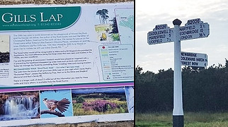
If you had stayed on the driveway you will also arrive here. Cross over the main road, going through a gap in the gorse bushes opposite the Old Lodge drive entrance. When you reach a track, turn left, following the Vanguard Way. It runs parallel to the road until it reaches a junction. Cross over to reach Gills Lap ('Galleon's Lap' in the Pooh books). Continuing along the Vanguard Way behind the tree clump will take you to a triangulation point on the right. Leave the Vanguard Way here and instead carry on straight ahead to A.A Milne's memorial, which is on a rock at 'The Enchanted Place'. A good spot to rest before the final leg of the walk.

Cut diagonally across the field and carry on across the next one in the same direction, heading uphill towards Gallipot Hill Farm. When you reach the corner of the field, climb over the stile, turn right and follow the path around, as it passes some fields and then goes through a wood (we heard an owl here – was it actually 'Owl'? Who knows...). When the path reaches a lane, turn right to walk into Hartfield, a lovely old village with a Winnie-the-Pooh souvenir shop. Buses run from opposite the Village Hall back to Tunbridge Wells, but we recommend a stop-off at the lovely Anchor pub first – the perfect place to raise a toast to Pooh Country.
Just after Pooh Bridge, there is a turning on the right. If you have time for a short detour, this lane will take you to Cotchford Farm (although it is barely visible). The farm was bought by A.A. Milne as a country retreat in 1925. This is where he wrote his Winnie-the-Pooh books, based on the adventures of the eponymous bear, his animal friends, and Milne's young son, Christopher Robin. The animals were based on Christopher's toys. He later resented his role in the books, although he once described his time at Cotchford in idyllic terms: 'So there we were with a cottage, a little bit of garden, a lot of jungle, two fields, a river, and then all the green, hilly countryside beyond, meadows and woods, waiting to be explored.' The garden contains statues of Christopher and 'Owl' and a sundial featuring the Pooh characters. Milne senior, who was apparently unhappy he had not been taken seriously as a writer and was only famous for his children's stories, died at the farm in 1956. Christopher never returned to Cotchford and his mother put the house up for sale.

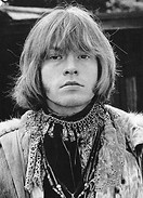
After being bought by an American couple, the property was purchased by Rolling Stones' guitarist Brian Jones in 1968. Jones had founded the Stones in 1962 and was the original leader of the band. However, tensions gradually grew within the group and Jones found himself increasingly sidelined as he fell out with their manager Andrew Loog Oldham. By the time he moved to Cotchford, Jones was alienated from the rest of the band, who were exasperated by his frequent mood swings, brought on by drug and alcohol abuse, and his absence from rehearsals. He was fired and replaced with Mick Taylor. Less than a month later, in the early hours of July 3, 1969, Jones was found dead from drowning in the swimming pool at the house. He was 27 years old. The verdict was misadventure, although there were theories, investigated by the police, that Jones may have been murdered. The Rolling Stones played a concert in Hyde Park two days after his death in front of an estimated audience of 250,000 people. KB
Walks by County
Listed by the most traversed
county for each route
Berkshire
Buckinghamshire
Henley circular
Pr. Risborough-Wendover
Tring circular
Tring-Leighton Buzzard
Cambridgeshire
Cambridge-Trumpington
Whittlesford-Wandlebury
Derbyshire
Edale-Hope
Dorset
Corfe Castle-W. Matravers
East Sussex
Ashdown Forest
Berwick circular
Berwick-Seaford
Cuckmere Haven-E'bourne
Forest Row-Eridge
Glynde-Berwick
Glynde-Seven Sisters
Isfield-Lewes
Lewes circular 1
Lewes circular 2
Lewes-Hassocks
Lewes-Rottingdean
Plumpton-Hassocks
Rye-Three Oaks
Gloucestershire
Kingham circular
Toddington-Cleeve Hill
Hertfordshire
Codicote-St Albans
Odsey-Royston
Kent
Oxfordshire
Surrey
West Sussex
Bramber-Amberley
Steyning circular
West Yorkshire
Haworth-Hebden Bridge
Wiltshire
Avebury circular