

Full-day country walks in
SE England and beyond
Berwick circular
Distance: 10.6 miles.
Time without long breaks: Apx 5 1/2-6 hours (add time for pub breaks)
Terrain: Easy and mostly very flat.
How to get there and back: Train to Berwick station, on the London to Eastbourne line (you may need to change at Lewes).
Pub breaks: There are just two pubs on this walk – both called The Yew Tree. One at Chalvington and one at Arlington. If you have a wait at Berwick for the train, the Berwick Inn is just over the road.
More information: There are a few local footpaths on this walk which aren't particularly well sign-posted and don't follow the exact route as displayed on the OS maps. We've highlighted where this happens and suggest you follow the map here and the directions as set out below.

Click on the image below to access the full map on plotaroute

The name of this walk is a bit misleading as it doesn't visit the main part of Berwick village, which lies south of the A27 (see walk 24). Instead, it is a circular walk from the station that bears its name. It does, though, include four other beautiful villages – Selmeston, Ripe, Chalvington and Arlington – located in the flatlands to the north of the South Downs ridge. Other highlights include two country pubs and Arlington Reservoir nature reserve, a haven for local wildlife. It is a walk with a significant literary connection. Malcolm Lowry, the writer of Under the Volcano, lived in Ripe in the final years of his life (see panel below).
Turn south when exiting the station. Opposite the Berwick Inn, you will spot a sign for the Vanguard Way. Walk up the path alongside a metal building, which leads to an open field. Cross over the field following the path and go through the gate on the other side. Follow the edge of the next field along the hedgerow with views towards the Downs and Firle Beacon to your left. When you reach Stonery Farm on the right, cross over the track and carry on straight ahead through a gate. The path runs between hedges and then through some trees before passing a house on the left. The track becomes a lane. Just past a house on the right, you will see a footpath coming off on the right-hand side, which leads into the back of the churchyard of Selmeston Church.

Enter the field and head for the far right corner, where there is a bridge into the next one. Continue in the same direction, aiming for a stile, and then cross over the following field. The path may be obscured here but cut across as before. You will see a gate and a stile, beyond which is a flint barn. Go over the stile, turn right and walk up to the railway crossing. Cross the tracks and follow the hedgerow on the other side. After about 150m, look for a gap in the hedge on the left and a small wooden bridge. Cross over this into the next field. There should be a clear diagonal path here which heads across to a small wooden gate on the other side. Go through the gate and the trees to emerge at the corner of a field.

It's a similar story for the next field. Turn left after going over the stile, follow the bottom of the field, then turn right towards the top corner. Just along from the corner, you will see a stile. Cross over this onto Langtye Lane. Go straight over and go through the grounds of a house aiming for a small wooden gate. Head through this and follow the path straight ahead through the field and some trees. Go through two metal swing gates to emerge at the corner of a field. As before, the path here seems to have vanished. Turn left along the bottom edge, passing the electricity pylon, until you reach the fence. Walk up the side by the fence. Near the top corner, take the track on the left that leads to a gate onto a road.
Return back to the road, turn right and follow it past some houses until you come to the turning for Ripe Church, where Malcolm Lowry is buried (his grave is in the little section at the front of the churchyard). There is a small white gate and some steps at the far end of the churchyard that lead back on to the road. Continue along the lane for about half a mile until you reach a junction with a signpost. Turn left here. After about another half a mile you come to the Yew Tree Inn (the first of two pubs on this route called the Yew Tree).

This is another place where it's easy to get lost. The footpath isn't marked, but it crosses a series of largely unenclosed sheep fields in a south-easterly direction. If you turn right shortly after going over the stile, you will meet a narrow path crossing the field towards the left side of a large tree. Take this path and turn right to go around the tree. You will then meet another similar path through the grass. Follow this to a two-armed wooden footpath sign. Aim for the bottom left corner of the next field, where you will find a stile in the hedge (quite overgrown when we did it). Go straight across the final field and over a stile to reach a tree-lined bridleway.

After leaving the church, continue down the lane and go through the gate into a farmyard. Straight ahead, past the barn conversion, you will see a gate. Don't go through this, but turn right by the wooden railings, following the footpath sign, and head down the field with a hedge on your left. About 3/4 of the way along the field, turn off left at the signpost, crossing over a stream, then head diagonally across following the path to the right of an electricity pylon. When you reach the next field, turn left and then go through the gap in the hedge. Cut diagonally across this field to the opposite corner and cross over the stile onto a lane.

Just before you reach the house, take the farm gate on the left by the sign and follow the path as it heads downhill. At the bottom, go through 'Harvey's Gate' then carry on along the grassy track. Go over a stile and past a flint barn on your right, with Ludley farmhouse to your left. Walk down to the gate and then turn right down the farm driveway. About 300m on, the Vanguard Way bears off to the right. Unless you want to do a shorter version of the walk (in which case this will take you back to Berwick Station), ignore this and carry on down the lane which passes Berwick Village Hall (the band Sea Power once held a festival here). When you reach the road, cross over turn left and walk up the verge.

A path merges and a bridleway forks off, but keep along the track through the trees until you eventually reach a metal gate. Go through this and then turn immediately left over a wooden stile into a field. Walk across the field following the path, with the spire of Arlington Church in the distance. Go over a small bridge, then carry on to a metal bridge over the River Cuckmere. Cross over, then follow the path left in the direction of the church spire. Go over the stile at the edge of the field to a path that runs along the hedge. You soon come to another bridge on your left by a wooden sign, indicating the direction of far-distant Wilmington and Selmeston churches. (this is part of the Cuckmere Pilgrim Path).
On leaving the pub take the road straight ahead (in the direction of Berwick, as displayed on the signpost). You will pass a community hall on your right. About 200m further down, just past Copyhold Barn, look for a path through the hedge on the right marked by a low stone footpath sign. The path runs alongside a tall fence and then goes through a white gate. Take the gate beyond this and rather than follow the path that goes off to the right, head alongside the fence to your left (the path here may well be overgrown). You will shortly reach a better marked path crossing it. Turn left here to go over the stile and enter the next field.

Turn right. A few metres along you will see a footpath sign pointing towards a farm gate on the left. Go through the small swing gate which is next to it and walk up the field alongside the fence to your left. There are great views behind you here of the Downs and the reservoir. When you reach another gate at the top, turn right along the fence and then follow it round sharply to the left. The path then heads downhill to a pair of swing gates. Follow the well-marked path through the field on the other side, proceeding through a gate towards some houses. Go through another gate to reach the road. Berwick station is immediately on your left.

There has been a church here for well over a thousand years, although the present structure was built in Victorian times. The area around the church was excavated in the 1930s and revealed evidence of a Mesolithic settlement. Leave the church via the lychgate and head north up The Street, passing some old houses. Look out for a signpost on the right after about 300m (it may be hidden in the hedge). This points to the footpath on the left which starts as the driveway between two houses (just after the sign for Grey Cottage) and leads to a gate. After passing alongside the houses, go over the stile by the gate into a field.

The next section is difficult to follow on OS maps as the marked footpaths have been grown over or diverted, so best to follow the map linked to on here and the instructions below. When you emerge through the trees, turn left and follow the bottom edge of the field. On reaching the corner, turn right and walk up the side, following the field round a bend and up to the far corner. Here you will find a chalk track leading to the field on the left. Go through the gap and then go straight ahead across the scrub aiming for the right side of a small clump of trees. On reaching the trees, follow the hedgerow round along the bottom of the field. When you get to the corner, turn right and go up the track along the field's side to the top corner where you will find a stile.

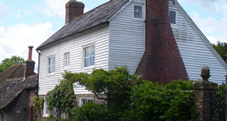
Turn northwards up the lane to the village of Ripe, following the road round to the right at the traffic island, past some old houses. When you reach the junction at the centre of the village, turn right, following the sign to Chalvington. On the right is the site of the old Lamb Inn. The closure of any village pub is a cause for lament, although this particular one did not have the best of reputations. Immediately to the right, by the village bus stop, is Channers Lane. Turn down here to reach White Cottage, once home to the writer Malcolm Lowry (see panel below), as revealed by the blue plaque.

This old country pub (one of Lowry's old haunts) has a huge garden. In the summer they sadly close the pub itself and decamp to a large marquee, which has taken away a lot of its charm. But it's still a good place to stop for a well-deserved pint or some food, especially as you are now approaching the half-way point of the walk. You leave the pub via the back of the beer garden. Head for the gate in the left hand corner which leads to the cricket pitch and camping field. Head straight across the cricket pitch aiming for a stile in a gap in the hedge on the other side.

You are back on the Vanguard Way. Follow the track through the trees. It emerges at a bend in a road. Turn right and follow the lane into Chalvington village. You will soon find yourself back at the crossroads where you were earlier. This time, turn left down Church Farm Lane. On the right, past some houses, you will come to the beautiful small church of St Bartholomew. The gates on the other side of the churchyard, which lead to a horses field with views towards the vista of the Downs, are dedicated to a local navy officer who died on HMS Martin during World War II.

Take a left and a few meters along, before you reach the house, go over a stile on the right, back on to the Vanguard Way. Follow the hedge on your left, with views of the Downs on your right. At the corner, go over another stile. Take the path that cuts straight across this field and leads to some steps and a gate on the other side. Head up the next field towards the farm, aiming for a wooden gate into the farmyard. Walk up the track with a metal barn on your left. Then turn left to reach a road and go through the gate next to a small barn conversion and follow the track round. The front of Georgian Mays farmhouse is on your right.

After 250m, turn right through a wooden gate following a sign marked 'Fishing Lodge'. Just before some metal gates on your left, turn up the path to reach Arlington Reservoir and nature reserve. There are picnic tables here and it's a great spot to rest (if you don't mind being bothered by the geese). Built in 1971, the reservoir is home to a range of wildlife, particularly of the avian variety. Birds you might encounter include osprey, kingfishers and great-crested grebes. The nature reserve also extends to the surrounding grasslands and wildflower meadows. Turn left at the information sign and follow the circular walk clockwise.

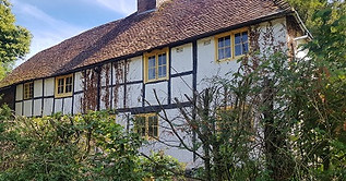
Cross over the wooden bridge and follow the path. Where it divides, take the fork on the left towards Arlington church. This leads to small gate at the back of the churchyard. The church, which is dedicated to St Pancras, dates from the 11th century. The East window is dedicated to the Victorian Amazonian explorer William Chandless. Leave the church via the lych gate and turn left past some beautiful half-timbered houses to reach the second Yew Tree Inn. You still have about 1 1/2 miles to go, so this lovely village pub is perfect for a break before the final section of the walk.

You are now briefly on the Wealdway. Follow the track through the meadow. After passing a house, go over a stile by a gate and turn right down the lane. When you reach the bottom of the lane, turn right and go across a road bridge with blue railings. Just after the bridge, take the footpath on the left, opposite some gates on the right, that goes through the woods. This emerges back at the road. Cross over and take the stile opposite by the footpath sign. Follow the hedge to your left and then go over the stile ahead into some trees. Cross over another stile and you will see a further rather strange stile in the fence on your left. Climb up over this and go through the grounds of a private house to reach a lane.


Malcolm Lowry spent the last two years of his life at the White Cottage in Ripe and is buried in the village churchyard. His best-known work by far is Under the Volcano. Based on the events of one day during the Mexican Day of the Dead festival, its focus is an alcoholic consul, Geoffery Fermin, who is trying to repair his relationship with his ex-wife as he heads from bar to bar, off his head on mescal. Fermin's character mirrored aspects of Lowry's, and the novel is regarded as semi-autobiographical. Richly symbolic, it took Lowry ten years to write and was originally intended as part of a trilogy based on Dante's Divine Comedy. After living in Mexico, the US and Canada, Lowry moved back to England with his second wife, Margerie, in 1955. He was making progress with his battles against alcoholism and mental illness, but he was not well-liked by the locals, who regarded him as a drunken lout. His unruly antics got him banned from his local, The Lamb, so he drank instead at the Yew Tree in Chalvington.
Lowry was at the Yew Tree with Margerie on the day of his death, 26 June 1957. Purchasing a bottle of gin at the bar, they left the pub in the early evening for the walk home along the lanes to Ripe. On returning to the cottage, the couple had a violent argument. Lowry was discovered dead the following day by his wife, who had slept next door. The official verdict was death by misadventure due to alcohol and drug poisoning. Suicide also seems likely, while an article in The New Yorker claims he was murdered by Margerie. According to the documentary Volcano, only seven people attended Lowry's funeral. He had written his own humorous epitaph: 'Here lies Malcolm Lowry, late of the Bowery, whose prose was flowery, and often glowery. He lived nightly and drank daily, and died playing the ukulele.' Sadly, it is not on his gravestone. KB

Walks by County
Listed by the most traversed
county for each route
Berkshire
Buckinghamshire
Henley circular
Pr. Risborough-Wendover
Tring circular
Tring-Leighton Buzzard
Cambridgeshire
Cambridge-Trumpington
Whittlesford-Wandlebury
Derbyshire
Edale-Hope
Dorset
Corfe Castle-W. Matravers
East Sussex
Ashdown Forest
Berwick circular
Berwick-Seaford
Cuckmere Haven-E'bourne
Forest Row-Eridge
Glynde-Berwick
Glynde-Seven Sisters
Isfield-Lewes
Lewes circular 1
Lewes circular 2
Lewes-Hassocks
Lewes-Rottingdean
Plumpton-Hassocks
Rye-Three Oaks
Gloucestershire
Kingham circular
Toddington-Cleeve Hill
Hertfordshire
Codicote-St Albans
Odsey-Royston
Kent
Oxfordshire
Surrey
West Sussex
Bramber-Amberley
Steyning circular
West Yorkshire
Haworth-Hebden Bridge
Wiltshire
Avebury circular