

Full-day country walks in
SE England and beyond
Bishops Cannings circular
Distance: 14.4 miles (or 15 miles with diversion).
Time without long breaks: Apx 7 1/2 hours but add time for pubs.
Terrain: A few hills, but nothing too steep.
How to get there and back: Catch a train to Swindon and from the bus station (3 mins walk), catch a No 49 to Bishops Cannings. Buses run hourly and take about 40 minutes. Catch the same bus back.
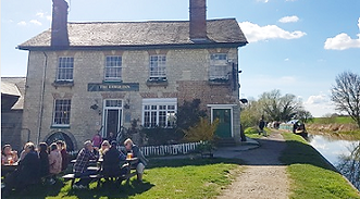
Pub breaks: One of our favourite pubs is on this route – the Barge Inn at Honeystreet, which is situated just over half-way through the walk. A couple of miles further on there is the Kings Arms at All Cannings. The walk ends at the Crown in Bishops Cannings. The bus stops outside.
More information: This is an area rich in prehistoric monuments and if you are catching the bus from Swindon, it will take you through the World Heritage Site of Avebury and its stone circles (see walk 51). Some of the route is along canal paths, which can be muddy so the walk is best undertaken after a period of dry weather.
Click on the image below to access the full map on plotaroute


This walk begins and ends in the Wiltshire village of Bishops Cannings, a short hop on the bus from Swindon. Following the Wansdyke, an old defensive fortification that runs for many miles along the ridge of the North Wessex Downs, it includes the Alton Barnes White Horse and the huge neolithic long barrow known as Adam's Grave. You then descend to the Vale of Pewsey, and follow the scenic course of the Kennet and Avon Canal, via two pubs and the villages of Alton Barnes, Alton Priors and All Cannings, before completing the loop back to Bishops Cannings and the Crown Inn.
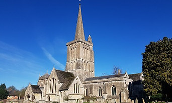
Alight from the bus at the Crown Inn stop in Bishops Cannings. Walk back past the pub and take the gate into the churchyard. The impressive parish church, dedicated to St Mary the Virgin, dates from the 12th century and was described by Nikolaus Pevsner as being of 'uncommon size and nobility' as it was part of the bishop's estate. The path becomes Church Walk. When you reach the lane cross over, following the wooden sign. Carry on in the same direction, crossing over a footbridge. The path cuts across the field, leading to a gate and a stile by a thatched house. Follow the lane around and, when you reach a meeting of lanes, carry on straight ahead until you reach a T-junction with a road.
Return to the track and cross over, taking the metal gate opposite, heading along the Wansdyke in an easterly direction. In about 1km you cross another track. Proceed via the metal gate opposite with a mound and tree beyond it. In 600m, follow the path as it turns left around some barns on your right, joining a track. When the track meets a junction, turn right then take the footpath on the left by the sign, going over a stile by a metal gate. Carry on. crossing over stiles either side of a track. The path descends via a metal gate to a chalk track with a cattle grid on your right. Cross over and go through the small metal gate to proceed.
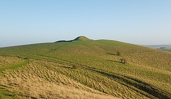
Follow the bowl, going through a wooden gate by a metal farm gate. You are now in Pewsey Downs nature reserve. The track swings right, following a grassy track. Go through another gate and turn left. Follow the fence on your left, going between gorse bushes to reach the top of Milk Hill escarpment. To your left, you will see Alton Barnes White Horse, which dates from the early 19th century. With far-reaching views below, this is a good place to stop and rest. To continue, turn left, aiming for the gate which leads to the chalk figure. Follow the path which runs above the top of the horse. As it swings to the left, you will see a prominent mound ahead of you. This is Adam's Grave.
Turn left and follow the grassy track as it runs parallel to the road for 250m, with horse paddocks to your right. Then take a right down a bridleway, which runs along the course of an old holloway between trees. It emerges at a driveway in the village of Alton Priors. When you reach the lane, cross over by the red phone box and head down Village Street, going past a long thatched barn. Follow the road around. It leads to a wooden gate to a field, in the middle of which the (now redundant) parish church is located. Exit the field on the other side of the church via two wooden turnstiles, crossing over a stream and following the stone paving.

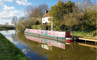
On the other side, take the path on your right down to the canal towpath. After about 300m, you will come to the Barge Inn – a great place take some time out and have a drink by the canal. The inside is full of quirky features, including paintings of crop circles. If you want a shorter walk, incidentally, there is a bus that runs from Devizes to Pewsey that stops at the turning for the pub (bookable in advance only – see the Salisbury Reds website – we managed to get a friendly local to order if for us!). To continue the walk, carry on along the towpath (which can get muddy), passing under Stanton Bridge and then England's Bridge.

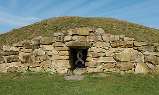
The diversion to All Cannings long barrow will add an extra 1/2 mile to your overall distance. Continue along the canal for 400m before you reach another bridge. Take the path up to the lane and turn right. In a short distance you will come to a wooden gate which leads to the field containing the barrow. Constructed in 2014 as a modern sacred place for 'people with no or any religion', it is also a Druidic place of worship and an internment site for ashes. You will need to make an appointment to view the interior. After visiting the barrow, head back the way you came but continue along the track after crossing the canal. This joins The Street in All Cannings, where you can pick up the route above.
Aim for the metal gate on the other side of the field, which leads onto a track. Carry on via the gate opposite along a path that is flanked by trees (this part was waterlogged when we last attempted it, so we simply walked across the field parallel to it instead). This takes you back to the canal and a swing bridge. Cross over the bridge (you may have to wait if barges are passing) and head straight up the concrete track on the other side. This crosses a stream to take you back to Bishops Cannings. Walk up The Street, turning left into Church Walk, where you were earlier in the day, retracing your steps to The Crown. The bus stop is located opposite the pub, by the turning for The Estate Yard.
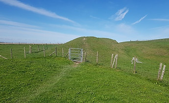
Turn right. Ignore the turning on your left by a red postbox but carry on down the road for just under half a mile. You will come to a red brick house, where the lane bends sharply right. Take the track on your left here into Easton Farm, going past a large barn on your left. The track becomes a public byway that ascends to the top of Roughridge Hill. There are strip lynchets (earthworks created by Neolithic farmers) to your left and right. The track flattens out as it nears the summit. The White Horse Trail crosses left to right via small metal gates (before the public byway at the top), following the banks of the Wansdyke, an early medieval defensive earthwork. If you go through the metal gate on the left, in about 200m you will come to Roughridge Hill long barrow.

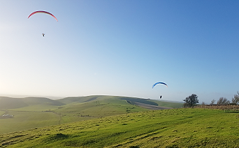
You will shortly come to a metal farm gate on your right with a smaller gate alongisde it. Go through this and climb up the bank to carry on along the ridge. Continue along this path, which offers superb views. You pass through gates and go alongside a fence on your right, beyond which are some tumuli. After about 2km, the path comes out at a lane via a wooden gate by a junction of tracks. Take the one on the right, ignoring the stile ahead. In a short distance you will come to a small wooden gate on your right. Go through this, following the route of the White Horse Trail. Pass through the wooden gate at the end of this field and follow the fence around to your left with the beautiful natural bowl, a popular spot for hang-gliding, down to your right.

A striking example of a neolithic long barrow, Adam's Grave is believed in local folklore to be the resting place of a giant. When the path forks, bear right to head towards the barrow. There are commanding views of the surrounding landscape from the top, including towards Knapp Hill to the east. Climb down from the other side of the barrow and bear right along a path that heads towards a road with a village (Alton Priors) visible to the left. The path passes some earthwork embankments before descending to a wooden gate. Go through the gate, going past a bench with some information boards. Take the footpath between bushes which emerges at a road. Cross over and take the steps opposite.

When you reach a crossroads of paths, turn left and head towards the 10th-century church of St Mary, Alton Barnes. On leaving the church, turn right and walk up the lane towards the road. When you reach the junction, turn left and walk down the road for about 1/4 mile, taking care to look out for the traffic. On reaching the hamlet of Honeystreet, turn right to enter Honeystreet Mill, located on the north side of the Kennet and Avon Canal. Here you will find a cafe, a farm shop and the Crop Circle Visitor Centre & Exhibition (this has long been a popular area for crop circles – see panel below). Exit Honeystreet Mill the way you came and turn right to cross the bridge over the canal.
After 1 3/4 miles along the canal, you will come to a car park on your left just before a bridge. You can turn off the canal here to walk directly to All Cannings. Alternatively, take the diversion to a modern long barrow (see next box). Turn left when exiting the car park and walk down the road. In 1/4 mile, turn right into Greenhouse Road to reach the village green. Bear left and head down The Street and in about 200m turn right into Pub Lane to reach the Kings Arms. On leaving the pub, carry on in the same direction, crossing over a bridge on your right to follow a path with a hedge on the right and a fence on the left. You then pass a lake on your right. Cross over a bridleway and carry on straight ahead along a grassy track that leads back to the canal.
When you reach the towpath, turn left. You soon go under Allington Bridge. This is a lovely stretch of the canal (look our for the herons). Continue along the towpath, passing a bench and an old swing bridge. At the next road bridge, walk up to the gate and turn left down the road into Horton. Follow the road around the bend, past a bus shelter. After the houses end, at a sharp bend, take a right up a concrete drive by a signpost, going through a wooden gate. Just before you reach Horton Mill Farm, turn left as indicated by the sign, past a barn. Then turn right and follow the path alongside a hedge. Take another right to go through a metal gate and head across the field, following the sign.

Every summer during the late 1980s and early 1990s, tabloid newspapers would be full of pictures of mysterious circles that had appeared in fields of crops overnight, with rife speculation on their origin. Could they be the work of UFOs, ley lines, cosmic energies, paranormal happenings or strange displays of sacred geometry? Or could it be the work of two fellas – Doug Bower and Dave Chorley – who ‘confessed’ to creating more than 200 of them? Whatever their origin, there was no denying their beauty and ability to intrigue. Crop circles are still a big deal – particularly in Wiltshire and Hampshire. Large scale ‘flattenings’ (fun fact: not always circles) appear from April to August attracting keen spotters called croppies. In fact, one summer’s day in 2013, A Trip Out was amazed to find a spotter from The Netherlands at the top of Silbury Hill, trying to get the best view of the newly-formed circle that had formed on Waden Hill, seemingly uninterested in the more ancient wonder beneath their feet.

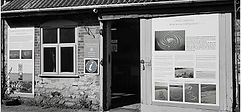

If you get your timings right on this walk, you can make a pilgrimage to the Crop Circle Visitor Centre & Exhibition. The centre is tucked away on the other side of the canal from the splendidly appointed Barge Inn in Honeystreet, where it used to be housed. Check out the pub’s pool room which has the surrounding landscape painted on the walls with our ancient favourites, the Devil’s Den, the Avenue and the white horses of Pewsey Vale, intermingled with the seasonal crop patterns. Benjamin Myers’ novel The Perfect Golden Circle focuses on two men who create the mysterious artworks – perhaps loosely based on Bower and Chorley. Writing in The Guardian, Myers said the novel places them in the longstanding tradition of 'pranksters, peasant revolutionaries and landscape dissidents’. He also praises the crop circle as being distinctly anti-capitalist – art for the people. Indeed, he is right. Crop circles are art in situ, a spotter’s delight, an added touch of beauty to the landscape already awash with more ancient man-made beauties. They add to the sacred landscape, inspiring awe, pilgrimage and celebration… with no admission fee or gift shop.
For enthusiasts, The Croppie has been running since 2015 and covers all things crop circle, including a great archive of different ‘seasons’ with aerial shots of the annual crop of field art. The Crop Circle Centre website contains reports of the latest circles. BH
Walks by County
Listed by the most traversed
county for each route
Berkshire
Buckinghamshire
Henley circular
Pr. Risborough-Wendover
Tring circular
Tring-Leighton Buzzard
Cambridgeshire
Cambridge-Trumpington
Whittlesford-Wandlebury
Derbyshire
Edale-Hope
Dorset
Corfe Castle-W. Matravers
East Sussex
Ashdown Forest
Berwick circular
Berwick-Seaford
Cuckmere Haven-E'bourne
Forest Row-Eridge
Glynde-Berwick
Glynde-Seven Sisters
Isfield-Lewes
Lewes circular 1
Lewes circular 2
Lewes-Hassocks
Lewes-Rottingdean
Plumpton-Hassocks
Rye-Three Oaks
Gloucestershire
Kingham circular
Toddington-Cleeve Hill
Hertfordshire
Codicote-St Albans
Odsey-Royston
Kent
Oxfordshire
Surrey
West Sussex
Bramber-Amberley
Steyning circular
West Yorkshire
Haworth-Hebden Bridge
Wiltshire
Avebury circular