

Full-day country walks in
SE England and beyond
Botolphs to Poynings via Devil's Dyke
Distance: 9.3 or max 10.9 miles with detours.
Time without long breaks: Apx 5 hours or 6 hours including the detours (plus time for pub).
Terrain: Nothing too challenging, but a few steep climbs, including the return from Fulking if you are taking the pub detour.
How to get there and back: Train to Shoreham-by-Sea then No 2 bus (or cab from the station). Return via a No 17 bus (or cab from the pub) to Brighton and then train. Buy a return ticket to Brighton and a single from Brighton to Shoreham.
Pub breaks: Apart from the three pubs In Bramber and Upper Beeding (all early on in the walk), there is the Devil's Dyke and, at the end of the walk, the Royal Oak in Poynings. There is also an optional diversion to the Shepherd and Dog in Fulking.
More information: You will need to coordinate bus and train times. The No 2 from Shoreham runs hourly (check here for times). The bus stop is six mins walk from the station (there is a taxi rank in case you miss it). You will also need to check the times of return buses to Brighton. At the time of writing they run hourly.
Click on the image below to access the full map on plotaroute
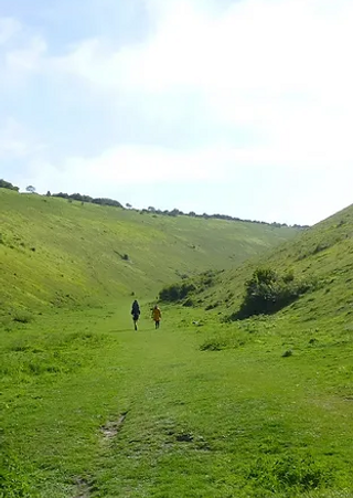

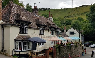
This route mostly follows the course of the South Downs Way from the Adur Valley to Devil's Dyke, the largest dry river valley in Britain and a famous beauty spot, offering what the artist John Constable once described as 'the grandest view in the world'. Beginning near the 11th-century church at St Botolphs, the route visits the historic village of Bramber and its castle ruins, before climbing to the ridge of the Downs. After Devil's Dyke, it descends to Poynings and the Royal Oak. If you fancy a longer walk, you can head down to the beautiful village of Fulking and its great pub, the Shepherd and Dog.
Exit Shoreham-by-Sea station and turn left onto Brunswick Road. After 150m, take a right into St Mary's Road to reach the parish church. Cut diagonally across the churchyard into Church Street. Head south until you reach the main road and the Adur estuary. Cross over to the bus stop. From here, you can catch a No 2 bus. Get off at the 'Upper Beeding, opp South Downs Way' stop, just past some old cement works (the journey takes about 12 mins). Head back down the road from the bus stop to the lay-by and follow the sign for the South Downs Way. The path runs parallel to the road before turning right and crossing a bridge over the River Adur.
Carry on along the Downs Link on the other side in the same direction. You emerge by a roundabout. Cross over to reach the entrance to Bramber Castle, the ruins and grounds of which are free to explore. The castle and the adjacent church were built in 1070 by William de Braose, a French nobleman who fought alongside William the Conqueror at the Battle of Hastings. There are a number of spooky tales associated with the site, which is allegedly haunted by the ghosts of three children (see panel below). Leave the castle by heading towards the church, but instead of going back down the entrance drive, bear left and then go down the path and some steps that lead to the main village street.

Head up the track. Turn left and follow the lane which leads to Truleigh Hill and its radio masts. There are far-reaching views behind you and to the north. After about a mile along the lane, you pass a rather ugly youth hostel on the left. You then pass some farm buildings and houses and then a barn and a mast. The track descends. After about 500m, with some gates ahead, there is a marker post and a National Trust sign. Just beyond this, if you take a left up a small path and over a hillock you will come to a bench with more fine views across the Weald. A nice spot to rest awhile. Return to the track and continue to the gates. You can just carry on along the SDW here, but we recommend you take a route closer to the escarpment which has more impressive views.

To exit the motte and bailey, take the stile by the side of the enclosure nearest the escarpment and then follow the path as it runs parallel to a fence. In about 300m, it swings right towards an electricity pylon. Turn left to rejoin the South Downs Way. You can either take the path nearer the edge or the parallel main track. This is Perching Hill and to the south is the location of the old medieval village of Perching, although nothing remains of the settlement today. About 500m on, you come to a wooden gate by a metal farm gate and a footpath marker post. There is an optional detour here. If you take a path on the left it will take you down to the Shepherd and Dog pub in Fulking (follow instructions in the next three boxes - otherwise skip to the main route below).
On leaving the pub, turn right along the main village street. Follow it around to the right at the junction, where it becomes Poynings Road. When you reach the bend ahead, take the driveway on the right marked Woodlands. In 50m, turn left up a footpath by a signpost. Go over the stile by the National Trust sign and proceed up the steps, which turn left. At the top of the steps, follow the path as it runs alongside a fence. It turns right and goes uphill between the trees, emerging through bushes with a signpost opposite. There are a lot of paths here, so follow the instructions below. For the next section, you just need to follow the signs for the bridleway.

If you've kept going along the South Downs Way, just past the gates and to the right is the site of Fulking Grange, an Isolation hospital that was set up in the early 20th century for patients with smallpox to keep them away from populated areas. About 700m further on, you reach some metal gates. Branch off from the SDW here, taking the left hand fork along the path that runs straight to the Devil's Dyke pub, with the Downs escarpment falling away to your left (just along here is where the detour above joins). The path goes over a small mound and then through a gate to emerge at the pub and car park, from where there are magnificent views. Ahead of you is a viewing point with a telescope, and some boards displaying the landmarks that be seen in three directions.

If you don't want to do the detour, just head up the road from the pub. There is a bus stop on your right (buses from here go to Brighton at weekends). Just past this on the left, on the corner of the turning to the car park, there is an information sign. Go through the small wooden gate and follow the path through the trees. You pass a children's play area which celebrates the Dyke's former incarnation as a Victorian amusement park (see panel below). Just after the trees end, you reach a marker post. Turn right down a path that leads to a gate (this is where the detour above joins). As you go through the gate, you will see a bench up to your right, from where you can view the entire length of the valley. Head down to the valley bottom and walk along the old river bed.

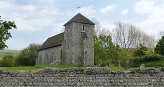
Head along the bridleway through the woods, ignoring the footpath that comes off to your right at a wooden signpost. Shortly after this you will come to another junction of paths and a marker post. Bear right, keeping on the bridleway. You emerge at a lane. Turn left, passing 14th-century Poynings church. Proceed to the road junction at Cora's Corner, which has a village shelter. Go through the archway to the left of the shelter and follow the path that runs alongside the road. You will soon reach the Royal Oak pub. The bus stop is about 1km (15 mins) walk away, but if you want to spend time here or don't want the risk of missing the bus, you can always skip the last bit and order a cab.


Head north up the opposite bank for about 200m and then turn left. You come out by a fire gate at a lane. Take a left here for a short walk to the Saxon church of St Botolphs (formerly dedicated to St Peter de Vetere Ponte, but the old bridge is long gone). This is a lovely, peaceful place. Head back up the road the way you came, taking the path back towards the river. This time, though, turn left before you reach it, following the sign for the Downs Link to Bramber. After half a mile, ignore the path that comes off to the right, but carry on ahead for about 150m to reach a crossing point over the A283. Take care crossing this busy road.

Head down the Street, passing the Castle Hotel on the right Hilaire Belloc's The Four Men mentions Bramber as having 'the best inn in the world' (see the panel on walk 31), but it is not known which inn was being referred to. Perhaps he meant the Castle or St Mary's House, an Elizabethan former inn and now a private residence which is open to the public. After passing the house, cross over the Adur again into Upper Beeding, passing the King's Head on the right. Bear right at the mini-roundabout and then when you reach the Rising Sun pub, turn left. After about 500m, turn right and proceed up The Bostal, following the wooden sign, until you reach the junction of the South Downs Way by a car park.

This alternate route will also take you to a motte and bailey (the earthworks of an old castle). There are two ways to get there. If the weather is dry and it's not too windy or slippery underfoot, take the gate on the left following the bridleway sign. When a footpath comes off to the left by a sign, turn right instead and walk up towards the fence. Then follow the defined path along the top of the steep coombes until you reach the banks of the old fort. There are views of Edburton and its church below. If you are feeling more cautious, or if surfaces are slippery, go through the gates straight ahead. You will see a round barrow ahead of you. Cut diagonally across the grass here to reach the fence on your left and follow it. In just under half a mile, cross over a stile on the left next to a small enclosure containing some dwarf trees.

Fulking detour: The detour, which is about a mile, means descending from the ridge and then making the climb back up (not as arduous as it sounds). Go through the gate on the left and follow the chalk path round and then down through a gully. After 300m, you will see two signposts on hillocks ahead of you. Take a left here to come to a third signpost. Follow the sign pointing west (public footpath), taking the grassy track that swings down to the right towards trees. Passing a marker post, the path proceeds down some steps through a wood. Cross over a stile and continue on the path as it runs alongside a fence. It leads to some steps. Go down these to reach a small lane and turn left for the pub.
Turn right at the signpost. The track bends uphill to the left to a marker post. Turn left here, following the track. You pass a large tree and a waymarker on your right before reaching another signpost at a junction of paths. Turn right (still following the bridleway). You can either take the main track or the parallel higher path that runs alongside it. In about 100m you come to the twin signposts you passed on the way down. Turn left here, up the chalk slope. This becomes a grassy track. You pass a bench as it heads uphill along the side of the escarpment towards the ridge. Go through a gate and continue walking up to the ridge path, turning left when you meet it towards the Devil's Dyke pub in the distance.

Hill fort detour: If you want to explore the iron age fort, there is a half mile detour you can take along its banks (otherwise skip to the next box). From the viewing point, carry on along a grass track, passing a marker post with a car park to your right. This becomes a chalk path running parallel to the escarpment (to your right, you can catch a glimpse of the sea). The path turns right and then crosses a track (you will see a farm gate to your left). About 75m down from here, take the right fork at a clump of bushes. Walk down to the chalk track and turn right, with the steep sides of the valley to your left. You pass the concrete footings of a cable car that used to cross to the other side (see below). When you reach a marker post, turn left and walk down to a gate.

The spectacular valley seems like it belongs more in the Lake District than Sussex. The legend associated with the dyke is that it was created by the Devil, who was trying to build a trench to the sea to drown the people of the Weald because of their conversion to Christianity. He was valiantly foiled in his attempts by St Cuthbert of Steyning. Proceed along the path, with the banks high on either side of you. You will come to two mounds, said to be the graves of the Devil and his wife (if you hold your breath while running backwards seven times around them, the Devil will apparently appear). The track bends to the left and then heads towards a gate. Go through this to leave the valley.

To reach the bus stop, come out of the pub and turn into the car park. Take the concrete path ahead that runs between trees. Continue via a gate. The path emerges at a road by a house with a clock tower. Take the footpath opposite that runs past the side of a school, following the sign. Go over the stile and follow the edge of a field to a bridge. Cross over and head straight across the next field to a gate next to a signpost. Follow the direction of the left-hand sign, cutting diagonally across the field towards the road junction. You come out by a gate next to a roundabout. Cross over the road and you will see a brick bus shelter on the other side. From here, you can catch a No.17 to Brighton.
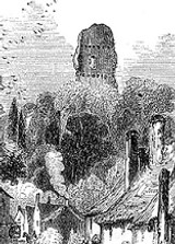
Founded by William de Braose, Bramber Castle remained within the family for many years, but in the 13th century it was captured by King John. He was becoming wary of the latest Braose incumbent (another William) and his growing influence. William fled to France disguised as a beggar, but his wife and children were imprisoned in the dungeons at Windsor Castle, where they were starved to death. According to local lore, the ghosts of the children returned to their home at Bramber and can sometimes be seen in the castle grounds, dressed in rags and begging for food. It is not the only ghost story associated with the site. You might also want to watch out for a white horse galloping around the moat. The spectral mare belonged to William de Lindfield, who was having an affair with Maud, wife of Hubert de Hurst who owned the castle at the time. Arriving on his horse to meet Maud in the 'pleasure house' in the gardens, he was caught by Hubert who bricked him up alive in a vault. Distraught on hearing of her lover’s fate, Maud died shortly afterwards. She too is said to haunt the castle, wandering its ruins wailing for her lost love.
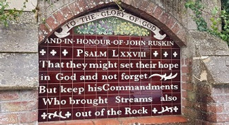
Devil's Dyke has also attracted many myths, but it was actually formed, not by the Devil, but by a river around 14,000 years ago. Its position made it the ideal location for a hill fort and during the iron age, vegetation on the hillside was cut back to reveal the bare white chalk, making it a landmark that could be seen for miles around. In Victorian times, following the construction of a rail link, the Dyke became the site of an amusement park. Built by game hunter and explorer J. H. Hubbard, the funfair – which had attractions including a rudimentary rollercoaster ride – proved wildly popular, attracting a million visitors a year. A funicular railway was also built (linking the Dyke to Poynings), as well as a precarious-looking cable car which passed over the valley. Amazingly, there is surviving film footage of the park in its heyday. KB

Walks by County
Listed by the most traversed
county for each route
Berkshire
Buckinghamshire
Henley circular
Pr. Risborough-Wendover
Tring circular
Tring-Leighton Buzzard
Cambridgeshire
Cambridge-Trumpington
Whittlesford-Wandlebury
Derbyshire
Edale-Hope
Dorset
Corfe Castle-W. Matravers
East Sussex
Ashdown Forest
Berwick circular
Berwick-Seaford
Cuckmere Haven-E'bourne
Forest Row-Eridge
Glynde-Berwick
Glynde-Seven Sisters
Isfield-Lewes
Lewes circular 1
Lewes circular 2
Lewes-Hassocks
Lewes-Rottingdean
Plumpton-Hassocks
Rye-Three Oaks
Gloucestershire
Kingham circular
Toddington-Cleeve Hill
Hertfordshire
Codicote-St Albans
Odsey-Royston
Kent
Oxfordshire
Surrey
West Sussex
Bramber-Amberley
Steyning circular
West Yorkshire
Haworth-Hebden Bridge
Wiltshire
Avebury circular