

Full-day country walks in
SE England and beyond
Bramber to Amberley
Distance: 15.6 miles.
Time without long breaks: 8 1/2 hours (add time for pub breaks).
Terrain: One quite steep climb to the top of the Downs.
How to get there and back: Train to Shoreham-on-Sea, then a No 2 bus to Bramber. Catch the train back from Amberley. You will need to buy two single train tickets.
Pub breaks: The newly reopened Frankland Arms in Washington is half-way along. Amberley village has another pub that has recently reopened – The Black Horse. The walk ends at Amberley station, which is adjacent to The Bridge Inn.
More information: You will need to coordinate bus and train times. The No 2 from Shoreham runs hourly (check here for times). The bus stop is six mins walk from the station. There is a taxi rank in case you miss it. The return bus goes directly to the station. The last section of the walk, through the water meadows at Amberley, is liable to flooding.

Click on the image below to access the full map on plotaroute

This walk largely follows the South Downs Way and runs (almost) between two castles – the ruins of Bramber Castle, built by a Norman nobleman, and Amberley Castle, now a luxury hotel. Starting in the historic village of Bramber, the route takes in some stunning scenery along the ridge of the Downs, including Steyning Bowl, Chanctonbury Ring and Rackham Hill. It ends at Amberley, from where there is a short section along the River Arun to the station and the pub.
Exit Shoreham-by-Sea station and turn left onto Brunswick Road. After 150m, take a right into St Mary's Road and cut diagonally across the churchyard into Church Street. Turn left to reach the main road and the Adur estuary. Cross over to the bus stop. From here, you can catch a No 2 bus to the start of the walk (a journey of about 17 mins). Get off at the stop for St Mary's House on The Street in Bramber (just past the bridge over the river). This building dates from the 1400s and was originally a pilgrims' inn although it is now a private residence. The house and gardens are open to the public. Proceed up The Street. You pass the Castle Hotel (possibly the place the characters in Hilaire Belloc's The Four Men refer to as 'the best inn in the world' – see panel below).

On leaving the castle, head back down to the church, but this time take the track on the right, past the car park. When you reach the castle entrance, head down the slope to the left and cross the road by the roundabout. Then turn right and go over the next road to Maudlin Lane. Cross over this too. By the 'narrow road' sign, you will see a gap in the hedge. Go down the steps and through the gate to join the Monarch's Way. Head across the field, aiming diagonally for the far corner by a house, where you will find a gate leading to some steps down to a lane. Turn right, then take a right at the end of the road and then a left into Sopers Lane.

You are now on the South Downs Way, which you follow for most of the remainder of the walk. You will shortly come to a crossroads of paths and an unusual flint memorial to a local farming couple. Then simply keep on along the SDW (rather than turn off here onto the Monarch's Way), going past a triangulation point. There are views to the Weald to your right below. You then pass some woods on the escarpment at Lion's Bank. After about 1 3/4 miles, you will eventually reach the landmark of Chanctonbury Ring, from where there are expansive views of the surrounding countryside.

Continue in the same direction, passing the Chanctonbury Hill trig point to your right. After about 1km, you will meet a junction of bridleways. Follow the sign for the SDW, which takes a sharp right turn. The track goes through some trees and after another 1km reaches the drive to Frieslands on the left. Just after this, you will see a grassy footpath on your right, which runs along the edge of an old chalk quarry and leads to the village of Washington. Follow the footpath through the trees and then cross over the stile and head diagonally across a field. Cross two more stiles to reach a road. Turn right and walk up the road along the pavement.

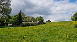
When you reach Rowdell Farm, follow the SDW left at the sign ignoring the turn off for the other bridleway and continue south past Home Farm Cottages. The track bears right through some trees, going steeply uphill. It then cuts across a field and passes through more trees, continuing its ascent back up to the top of the ridge of the Downs. It then swings left and at Barnsfarm Hill you will spot a farming notice and a log seat. Just after this, the alternative SDW route joins the main route. With views of Chanctonbury Hill to your left, turn right and head along the ridge.

Carry on in the same direction as before, following the waymarkers for the SDW to reach Amberley Mount. There are some more tumuli and a dew pond just south of the track at the brow. The path now descends quite steeply towards Amberley village, with some sweeping views of the Arun Valley ahead. When the path reaches the foot of the hill, ignore the broad track that bears left towards some farm buildings. Instead, keep on the SDW straight ahead. You will come to a gate which leads into some trees. Follow the path downhill to some wooden railings to a lane and turn right.
There is a memorial plaque here to the book illustrator Arthur Rackham and his wife, the artist Edyth Starkie, who lived in nearby Houghton (see the panel on walk 44). The church, which is dedicated to St Michael and dates from the 12th century, is located next to the castle, the grounds of which contain exotic birds. When we were there, the atmospheric graveyard was haunted by a stunning white peacock. Continuing along Church Street past the church will take you to a small green space with a stream and the back walls of Amberley Castle, which is now a hotel.

After a bend, you pass a footbridge on your right where the path merges with the South Downs Way. Keep on along the riverbank. The path runs behind some caravans and then emerges at a road by a railway bridge. Opposite you will see a small wooden garden gate. Cross over the road and go through the gate and down the path to reach the Bridge Inn., the perfect place to end the walk with a drink and some food. Amberley station – which is actually a fair distance from the village itself – is located very nearby, on the other side of the railway bridge. After leaving the pub, just walk around the road and under the bridge to reach it.
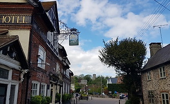
Further down, opposite the Old Tollgate Hotel, you will see a path on the right and some steps, with a sign to Bramber church and castle. They both date from the 11th century (the church is the oldest surviving Norman church in Sussex) and were built by William de Braose, who fought alongside William the Conqueror at the Battle of Hastings. Not much remains of the castle apart from the gatehouse tower, but it's a beautiful spot enshrined in local folklore (the castle is allegedly haunted by the ghosts of starving children who beg for food and the spectre of a woman weeping for her lover who was bricked up alive – see the panel on walk 12). It's free to get in and wander around the ruins and grounds.
After passing some houses, this becomes a country byway, with open views towards the Downs on your left. About half a mile along, you reach Upper Maudlyn Farm. Walk through the farmyard, passing barns and then a house on your right. Then join the concrete track that winds up the steep slope of Steyning Bowl. Although the climb is quite arduous, the great views when you reach the top make it well worth it. When you meet the road at the brow, turn right and follow the path that runs parallel to it. Cross over the road when you reach the wooden sign, then go through the gap in the hedge and continue in the same direction along the track.

Chanctonbury was the site of a hill fort during the bronze and iron age and was later used as a Romano-Celtic temple. The clump of trees was originally planted in the 18th century. The ring has long been associated with local myths and legends and is apparently still used as a site of ritual. Although it is a magnificent spot, venturing inside the trees can be an unsettling experience (for more on Chanctonbury, see the panel for walk 10, a circular route that links it with another prehistoric fort to the south, Cissbury Ring).

After about 300m you will come to the Frankland Arms, which has reopened after a period of closure. This also featured in Belloc's Four Men (see below). You are now almost half-way through the walk, so it's ideally located for a break and some food. It is also the last pub until Amberley. On leaving the pub, walk back the way you came and then turn right into The Street. The lane passes the church and then crosses over the A24. It continues on the other side, through some trees and into open countryside. You are still on the SDW here, but this is the alternative route.

After about 1 1/2 miles you will come to a junction of paths and a wooden signpost known as the Chantry Post. Ignore Chantry Lane on your right but carry on ahead along the SDW, passing some tumuli. A mile further along, on Kithurst Hill, you will come to another lane coming off on your right and a small car park. There are burial mounds here, too. Keep on the SDW. You will pass the triangulation point at Rackham Hill in the field to your left before reaching a junction of paths and a wooden sign by some prominent earthworks. Go through the gate and climb up the one on the right for some spectacular views to the west.

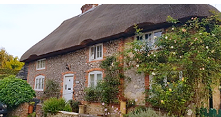
Just past the entrance to a large house, there is a junction of lanes. Take the right-hand fork. This is Mill Lane, which winds down into the village. Take care crossing over the road when you get to the junction and walk up School Road, which becomes Amberley High Street. At the top on the right you will find the Black Horse, another village pub that has reopened after a period of closure. Turn left by the pub and proceed down Hog Lane, which has some beautiful old thatched houses. When Hog Lane emerges at Church Street, take a right and walk down to the parish church.

Take the footpath that runs alongside the castle walls, go through the gate and cross over the railway tracks. Carry on the path straight ahead until you reach a field with a post on your left. You are walking across the river flood plains here, so be warned that it can easily get flooded in winter. Keeping the stream to your right, cut across the field and cross over a small bridge over a ditch. Head straight across the next field and then across a further one. Just before you reach the river, turn left at the sign. You can see the village of Bury on the other side of the bank. Follow the river south.


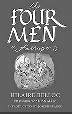
Although it follows a different route, this walk includes at least two of the pubs mentioned in Hilaire Belloc's The Four Men: A Farrago (1911). Belloc was a writer, historian, poet, satirist and Liberal MP. His books include a famous volume of comic verse, Cautionary Tales for Children. He was also a walker. The Path to Rome recalls a pilgrimage from France to Italy and he once trekked most of the way from Philadelphia to San Francisco in pursuit of his future wife. Belloc grew up in Slindon in Sussex and considered the county his spiritual home. Sometimes referred to as 'The Great Man of Sussex', he made frequent references to it in works such as The South Country, West Sussex Drinking Song and Ha'nacker Mill. 'Belloc Night' (27 July, the date of his birth), is celebrated in some Sussex locations by eating a cheese supper.
Combining three of Belloc's favourite things (walking, inns and Sussex), The Four Men is a fictional tale following four characters – Myself, Grizzlebeard, the Sailor and the Poet – as they undertake what is essentially a 90-mile pub crawl across the county, from east to west. It is also a homage to 'this Eden which is Sussex still' and a way of life that was under threat. Among the pubs the characters visit are the Frankland Arms in Washington ('the Washington inn all the world has heard of') and The Bridge at Houghton. Over the course of several pages, the men discuss 'the best inns in the world' (now that would make a pub crawl!). They conclude that none could ever beat 'the inn at Bramber' (it is not known where this was, but it could be what is now the Castle Hotel). Admirers of the book have attempted to walk the route and Bob Copper (see walk 34) traced the characters' footsteps in Across Sussex with Belloc. Inevitably some of the village pubs featured in The Four Men have since disappeared, a dispiriting trend that was close to Belloc's heart. 'When you have lost your inns, drown your empty selves', he wrote. 'For you will have lost the last of England'. KB
Walks by County
Listed by the most traversed
county for each route
Berkshire
Buckinghamshire
Henley circular
Pr. Risborough-Wendover
Tring circular
Tring-Leighton Buzzard
Cambridgeshire
Cambridge-Trumpington
Whittlesford-Wandlebury
Derbyshire
Edale-Hope
Dorset
Corfe Castle-W. Matravers
East Sussex
Ashdown Forest
Berwick circular
Berwick-Seaford
Cuckmere Haven-E'bourne
Forest Row-Eridge
Glynde-Berwick
Glynde-Seven Sisters
Isfield-Lewes
Lewes circular 1
Lewes circular 2
Lewes-Hassocks
Lewes-Rottingdean
Plumpton-Hassocks
Rye-Three Oaks
Gloucestershire
Kingham circular
Toddington-Cleeve Hill
Hertfordshire
Codicote-St Albans
Odsey-Royston
Kent
Oxfordshire
Surrey
West Sussex
Bramber-Amberley
Steyning circular
West Yorkshire
Haworth-Hebden Bridge
Wiltshire
Avebury circular