

Full-day country walks in
SE England and beyond
Corfe Castle to Worth Matravers
Click on the image below to access
the full map on plotaroute
Distance: 9.8 miles.
Time without long breaks: 5 hours walking, but add time for castle visit, heritage railway and the pub at the end.
Terrain: Some fairly steep dips and climbs along the coastal path and rocky in places.
How to get there and back: Catch a train to Wareham from Waterloo and then a No 30 or No 40 bus from Wareham to Corfe Castle. Then travel on the Swange Railway to Harman's Cross (or get a No 30 bus). Return on the No 40 from Worth Lane to Wareham and then train.
Pubs: Apart from those in Corfe Castle, there's only one pub and it's near the end of the walk. It's a great one, though – the Square and Compass.
More information: It may seem a long way to go for a day trip from London but it's perfectly feasible if you leave early and plan ahead. Trains to Wareham take about 2 hours 20 mins and the buses to Corfe Castle (which go from the station) about a further 20 mins. You will also need to check the times of trains from Corfe Castle to Harman's Cross here.


This is a fabulous all-day walk along part of the Jurassic Coast World Heritage Site, incorporating a section of the South West Coastal Path. Starting at Corfe Castle, you catch a heritage train to Harman's Cross. You then head south to join the Priests Way, where you can visit an old quarry which contains fossilised dinosaur footprints (see panel) before descending to the cliffs at Dancing Ledge. The rest of the route takes you along the coastal headlands with their unique geology to St Adhelm's Chapel, before turning north to picturesque Worth Matravers, home to one of the best pubs in the country.
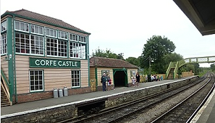
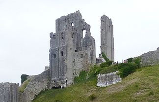
On arrival in Wareham, head for the footbridge, cross over and take the exit from Platform 1. Walk down to the roundabout and on your left you will see the bus stop, where there are regular buses to Corfe Castle (check Traveline for times). The village is named after the castle which towers over it, a famous Dorset landmark which was built by William the Conqueror in the 11th century to defend a strategic gap in the Purbeck Hills. It was substantially renovated during the reigns of kings John and Henry III and remained a royal fortress until it was sold by Elizabeth I. During the English Civil War it was the scene of a siege, eventually falling to Cromwell's forces (see below). Today it is a National Trust site – check here for opening time and prices.
Go over a stile into the next field and carry on in the same direction, with a stone wall on your right. You emerge via a stile onto a road. Turn left and then right to continue heading south along a chalk track. When you reach the farm, turn left along Priest's Way. This is an old route which was used by clergymen in the Middle Ages to walk between St Nicholas' church in Worth Matravers to St Mary's in Swanage. About 400m along from the farm, on your left at Spyway, you will see a signpost to Keate's Quarry, a National Trust site which contains dinosaur footprints dating back 145 million years. There are around 100 footprints in total (see panel below).

This popular beauty spot and old smugglers' haunt has a rocky beach if you fancy hunting for fossils. Return back up the steps to the stile and turn left onto the South West Country Path long-distance footpath, which forms much of the remainder of the walk. Head along the path over the headlands, with a fence separating you from the cliff edges and spectacular views over the sea. About half a mile from Dancing Ledge, the track turns briefly inland at Hedbury Quarry, a popular site for rock climbers. Look out for an odd cow monument in a stone wall. The track then rejoins the coastline, continuing via a wooden gate parallel to the clifftop fence.

Back along the coastline, you pass some strip lynchets in the fields on your right, a sign that the land was used for farming many centuries ago. A mile from Winspitt you will reach St Adhelm's Head (also known as St Alban's Head), which marks the most southerly part of the Purpeck peninsula. Here you will find the radar memorial, which commemorates the radar research carried out at Worth Matravers during the Second World War which played a role in the birth of modern telecommunications. Just past here is a National Coastwatch Institute station (not to be confused with HM Coastguard), underneath which is another disused sea cliff quarry.

The chalk track soon bends left and heads north, passing St Adhelm's Head quarry (still in use). Just past here in the field on your left is the former site of RAF Worth Matravers and the Telecommunications Research Establishment, where early experiments with radar took place in the 1940s. About a mile down the track you will come to a crossroads of paths. Carry on straight ahead until you reach Renscombe Farm, which has an old farmhouse built from local limestone. Turn right here along the lane, passing some bungalows and Weston Farm. There are open views of the countryside on your right. You will soon come to the village of Worth Matravers.

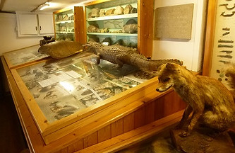
Originally two cottages, the pub – which has connections with smuggling – was originally called the Sloop. The name was changed in the early 1800s by the landlord, who was a stonemason. The pub is unusual as it contains no bar – drinks and food (and homemade cider fudge) are ordered via a serving hatch. It serves local ale from Hattie Brown's brewery, including a beer called Dog on the Roof (apt, as there is often a dog on the roof). There is a museum of fossils and assorted taxidermy, while the main room also contains a stuffed badger. It's a great place to end the walk, particularly if you can sit out the front on a sunny day, where you can just about see the sea. There is still one section to go, though, before you can start the journey home.

The village itself is also worth exploring. It is a stop on the Swanage Railway heritage line and you can catch a train from here to the start of the walk. The station is located on Station Road, off East Street. Alight the train at Harman's Cross (alternatively, catch a No 30 bus). From the station, walk up to the road, go through the gate and turn right to cross over the bridge. Carry on along this country lane bordered by hedges for about 3/4 mile, where it meets a B-road at a junction. Turn left. A short distance down on the right, by a car lay-by with a stone wall, you will see a footpath sign. Climb over the stile and head down the path.

Returning to the Priest's Way, carry on eastwards, passing an old barn on your left. About 1/4 mile further on, just past a pond, take a right through a gate and head down the chalk track. Keep on the track, ignoring the turning on your right to a house and passing a small disused quarry on your left. The track passes through a gate into scrub, heading downhill. When you emerge from the scrubland, follow the track as it heads down steeply through a field to reach a stile. Cross over the stile and take the steps down the cliffs to reach the sea at Dancing Ledge (so called because in stormy weather the waves dash against the natural ledge in a dancing motion).

A further half mile on, after passing through a gate by a stone wall, the track turns inland again at Seacombe Cliff. After about 300m, turn left through a wooden gate and proceed up Seacombe Steps. At the top there is another gate. Turn left and follow the track through the scrub back to the coastline. Keep going along the clifftops, following the route of the SWCP via two wooden kissing gates. It heads inland again to skirt around Winspitt Quarry, which has some old quarry buildings. The site has been used as a location for film and TV series, including Doctor Who and Blakes 7.

Just beyond the coastal lookout is St Adhelm's Chapel, which dates from Norman times. It lies in an earthwork, which suggests the site was in use before the chapel was built. Although it was listed as a chapel in the 13th century, the central column and lack of an altar also suggests the building may have had another purpose when originally constructed. Weekly services, attended by coastguards and local families who lived in the nearby dwellings, were still held here up until the early 1900s. On leaving the chapel, rather than continue along the South West Country Path, turn right along a track that swings right past the cottages.

When you get to a road junction, follow the lane around to the left to reach the parish church of St Nicholas. This is one of the oldest churches in Dorset, dating from around 1100. An interesting feature are the figures on the corbel under the roofline, which include a rare sheela na gig. When leaving the church, turn left and continue along the lane past some tea rooms until you reach a junction by the village pond. Follow the lane around to the left to reach the Square and Compass, a pub in a Grade II-listed building with outdoor stone tables where the workers from RAF Worth Matravers used to drink. A stop-off here is not to be missed.
On leaving the pub, walk up past its left hand side. In the field on the left, is 'Woodhenge', a wooden reconstruction of Stonehenge built by the pub's landlord (he has since been asked to take it down, so it may no longer be standing!). A mile down the road you will come to the junction with the B3069. Turn left. You will see a bus stop sign attached to a telegraph pole. From here you can catch a No 40 bus to Wareham, from where you can get the train home. The walk from the pub to the bus stop should take about 20 mins, but add time if you want to have a wander around Woodhenge.
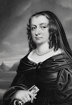
Corfe Castle stands sentinel over the village that bears its name, its jagged, angular walls a vivid reminder of its violent history. The ruins as you see them were caused by an attempt to blow it up following the English Civil War. The fort had been a formidable royalist stronghold surrounded by parliamentarian forces. Its owner, John Bankes, had left to fight for the King, leaving his wife Mary in charge. When the Roundheads arrived and demanded the castle’s surrender they were surprised when Mary and her maids responded with cannon fire. Mary called for reinforcements and royalist troops arrived, but they were still outnumbered. For six weeks, they repelled the siege by ‘heaving stones and hot embers’ over the walls. Eventually the castle fell when Mary was betrayed by one of her men, who led the Roundheads – who had reversed their jackets to disguise themselves – into the fort. According to lore, she threw the family treasures down a well to stop them from being captured. However, evidence now suggests that 'Brave Lady Mary' had sensibly already made her escape.

Another fascinating site to visit on this walk is Keates Quarry, home to the Spyway dinosaur tracks. The Jurassic Coast is unique as being the only place in the world where rocks from the Triassic, Jurassic and Cretaceous periods collide and the animal-life that previously resided here has been preserved in the form of fossils. If you were able to travel back in time 145 million years, you would find the area covered in swamps and humid forests. The fossilised footprints at the quarry suggest that back then it was probably a watering hole visited by the Brachiosaurus, a member of the plant-eating Sauropod family, which includes the largest animals ever to walk the earth. About 60 foot long, the Brachiosaurus could reach trees and plants 30 foot high and could weigh as much as 50 tons (five times the weight of an elephant). It has been theorised that it was the massive weight of these huge beasts, pressing down on the sedimentary rock, that created the footprints you can see today. KB
Walks by County
Listed by the most traversed
county for each route
Berkshire
Buckinghamshire
Henley circular
Pr. Risborough-Wendover
Tring circular
Tring-Leighton Buzzard
Cambridgeshire
Cambridge-Trumpington
Whittlesford-Wandlebury
Derbyshire
Edale-Hope
Dorset
Corfe Castle-W. Matravers
East Sussex
Ashdown Forest
Berwick circular
Berwick-Seaford
Cuckmere Haven-E'bourne
Forest Row-Eridge
Glynde-Berwick
Glynde-Seven Sisters
Isfield-Lewes
Lewes circular 1
Lewes circular 2
Lewes-Hassocks
Lewes-Rottingdean
Plumpton-Hassocks
Rye-Three Oaks
Gloucestershire
Kingham circular
Toddington-Cleeve Hill
Hertfordshire
Codicote-St Albans
Odsey-Royston
Kent
Oxfordshire
Surrey
West Sussex
Bramber-Amberley
Steyning circular
West Yorkshire
Haworth-Hebden Bridge
Wiltshire
Avebury circular