

Full-day country walks in
SE England and beyond
Cuckmere Haven to Eastbourne
Distance: 11.6 miles.
Time without long breaks: 6 1/2 hours (add time for the Tiger Inn).
Terrain: A large part of this walk is up and down the brows and dips of the seven sisters but it's not too strenuous providing you have a reasonable level of fitness.
How to get there and back: Train to Eastbourne and back. Catch one of the regular No 12 Coaster buses from Eastbourne to the Seven Sisters Park entrance (check here for times). You will walk back to Eastbourne, but there is the option of catching a bus (or getting a cab) from Beachy Head if you want a shorter walk (see below for details).
Pubs: We recommend The Tiger at East Dean, a lovely pub on the village green. There is also the Beachy Head pub and a cafe at Birling Gap.
More information: This route links with walk 1, which starts from Glynde near Lewes. It is possible to combine the two. The total distance would be 21.6 miles and you'd need to allow around 11-12 hours.
Click on the image below to access the full map on Plotarooute.com

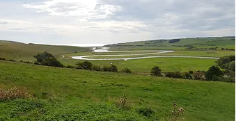
This walk begins at the entrance to the Seven Sisters Country Park, a 280-hectare nature reserve comprising a river estuary and chalk grasslands which provides the habitat for a wide variety of flora and fauna. You follow the Cuckmere River and its ox-bow lakes to the sea and then ascend the clifftop to follow the South Downs Way over the brows of the Seven Sister cliffs. There is a diversion inland to East Dean and the Tiger pub. The walk continues via the clifftop houses at Birling Gap to Beachy Head and its iconic lighthouse. From here, there are a variety of routes to take you back to Eastbourne.
From Eastbourne station, cross over the junction into Gildredge Road. The bus stop for the No 12 is just on the right (you can catch any of the No 12 services. Buses run apx every 10 minutes and take about 20 mins). Alight at the Seven Sisters Park Entrance stop, at Exceat. The bus stops right by the gate for the South Downs Way, but rather than go through this, head down the road for a short distance to reach the visitors centre on the right, where you can find out more about the Seven Sisters Park. Opposite the visitor centre is a red phone box and a road to a car park.

Head towards the cliff at the end of the beach. There are two options here. The shortcut is to climb up the path to the top of the cliff. It will depend on your bravery and head for heights whether you want to tackle this – but it's not as scary as it looks. However, it is a steep climb and should also not be attempted in wet weather or when the rocks may be slippery. The alternative (and easier) route is to head inland from the cliff along the path that tags the headland. You will soon come to a wooden gate on the right by a bench. Go through the gate and ascend through the field to meet the South Downs Way. Turn right and follow the path to the cliff top, which has great views of the estuary below.
Just past the small trees, you reach a larger clump on your left. Rather than carrying on ahead towards the house and car park, turn right and head towards the edge of the field at an angle of about 2 o'clock. Warning: there is no path here, so it can be a bit hard to find, but look for a small wooden gate with a metal gate alongside it. Go through the gate and head across the next field, and down the right-hand side of some trees surrounding a house. In the bottom corner of the field you will come to a metal gate with some steps beyond it. Don't go over the steps, but climb over the wall on your right, onto the steps on the other side.

When you emerge from the wood, head straight south, keeping the line of trees to you left. In about 300m, you will come to Red Barn, where a track merges from the right.The path then descends from Went Hill to reach a wooden gate by a house (Seven Sisters Cottage). Just after this, you are back on the South Downs Way, which joins from the right. Follow the lane past the houses to reach Birling Gap. There is a small collection of houses on the cliff tops here which it is feared will soon fall into the sea. You will also find a National Trust visitor centre which has a cafe and toilets. There are steps down to the pebble beach below.

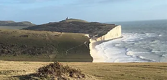
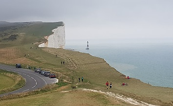
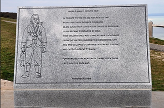
The beautiful headland where the lighthouse is located is the last (or perhaps first) of the Seven Sisters. it has sadly gained a reputation as a suicide spot and near the low-level circular watchtower you will find a plaque containing bible verse to dissuade people from throwing themselves off the cliff. The watchtower itself has a plaque to PC Harry Ward, the Downs Ranger who patrolled Beachy Head on his horse for many years and saved numerous lives, often at the risk of losing his. About 300m beyond this, with the Beachy Head pub on the other side of the road, you will come to the Compass Rose toposcope. Directly to the south of this is a memorial to RAF Bomber Command (some of the dogfights in the Battle of Britain were fought in the skies above).
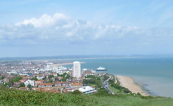
The first option is to follow the route of the South Downs Way, which runs inland from the coast, initally parallel to the road. There are lots of paths, so follow the waymarkers as it winds its way through scrubland and bushes, before descending through a field via steps and a slope to Duke's Drive on the edge of Eastbourne, where there is refreshment kiosk. An easier-to-follow route (marked as the main route on the map) is to head down the wide track which runs just to the left of the RAF memorial and after about 150m take a left along a path through bushes which joins a clear grass track. Follow this as it bends round the north side of a playing field. Shortly beyond this, take the left hand fork at a junction of tracks to join the route above and turn right.
Just past the phone box, go through the small wooden gate on the left (before the information board). The South Downs Way bears left up the side of the hill, but follow the track straight ahead instead, taking the path which runs nearer the River Cuckmere rather than the concrete road. After about 3/4 mile, the South Downs Way descends to briefly join this path at the turning for Foxhole, where there is a wooden signpost. Go straight ahead here following the beach trail, past another signpost, ignoring the SDW turn off and heading straight for the sea and the shingle beach.

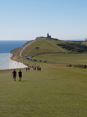
Walk along the top of the Seven Sisters, up the brows and down the dips, until you reach Flagstaff Point. There is a small monument here to Captain William Charles Campbell, a World War I fighter pilot (the cliffs here are often aptly frequented by bi-planes flying overhead). In the distance, on top of another brow, you can see Belle Tout lighthouse, but turn inland here, going through the small gate ahead. Walk through the field and then through a gate with a footpath sign. Head for a small clump of three or four dwarf trees on the horizon, passing Crowlink Farm in the valley on your left.

Head down the edge of the field towards the back of the houses. Go through the iron gate and down the path into the village of East Dean. Turn left onto Went Way and on the right you will come to the picturesque village green and the Tiger Inn. On the other side of the green, look out for the plaque to Sherlock Holmes. This was apparently the house Arthur Conan Doyle had in mind for the fictional detective's retirement. On leaving the pub, return the way you came, heading down Went Way and carry on down the lane. After passing Underhill House on the left, the lane ends and then becomes a track that enters some woods, leading uphill.

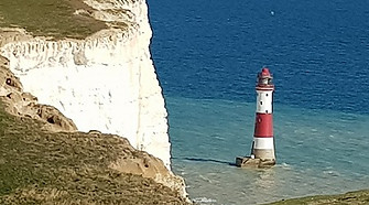
From Birling Gap, continue on the SDW by climbing up the headland via some steps to the Lookout, where there are some great views behind you. After just over half a mile along the clifftop path, you will come to Belle Tout lighthouse, which was built in 1832. It was decommissioned just 70 years later because its location meant sea fog was badly affecting the light's visibility. A short distance on from Belle Tout, you should be able to catch your first glimpse of its replacement, far down on the rocky beach below - the much more famous Beachy Head lighthouse.
If you don't feel like walking the final section, you have the option of finishing the walk here by catching the No 13X Coaster bus from the Beachy Head pub into Eastbourne. They are a lot less regular than the No 12 but run until about 5.30 on weekdays or 7pm at weekends. Check here for times. If you miss one, you can order a cab from the pub. There are three different options to continue to Eastbourne (all marked on the map). All of the routes start from the RAF memorial and end up at the same place, so it doesn't matter too much which one you take – just head in a direction parallel to the coast and you can't really go wrong.
The Wealdway runs closest to the sea. Head down from the RAF memorial but carry on until you reach the bottom and turn left. About 200m from a bench and a 'cliff edge' sign, you have a choice of either following the path along the cliffs or a wider parallel track. The path passes Cow Gap, where there are steps down to the beach (only safe at low tide). This route takes you across the bottom of the playing field and becomes a lane that meets the other routes at the kiosk. From Duke's Drive, head along the coast road. If going to the station, turn up Wilmington Square, go past the Towner Art Gallery, into College Road and then Gildredge Road. Or carry on along the seafront and turn left into Devonshire Place opposite the bandstand to reach the town centre.
In the early 1700s, roughly beneath where Belle Tout lighthouse is now, there was a cave known as Parson Darby’s Hole. Long before the lighthouse was built, shipwrecks were a common occurrence along this stretch of coastline. The bodies of sailors would be washed ashore and the bounty from the ships stolen by local villagers. Some, known as ‘wreckers’, would deliberately lure boats onto the rocks by tying lanterns to donkeys on the top of the cliffs, so passing ships would mistake the moving lights for other vessels and assume there was a safe passage. The rector of East Dean, Jonathan Darby, had to deal with the human consequences of the wrecks, whether caused by man or nature, burying the bloated bodies of drowned seamen in his churchyard. Fixated on preventing further deaths, he enlarged an old smugglers cave at the foot of the cliffs and equipped it with a static lantern – creating the first ever Seven Sisters lighthouse. He made it into a small home, adding a carpet and chairs. A shaft was also built connecting the cave to the clifftop, with a rope providing access.


Darby had been born in Westmorland and attended Oxford before being ordained and posted to the tiny Sussex community of Litlington (see walk 1). He then moved to the larger parish of Wilmington, Friston and East Dean. Two of his children died while young and when his wife also passed away, he would spend many hours alone in the cave, accompanied only by the lantern and the swell and crash of the sea. There has been some debate as to whether he was actually the hero he is portrayed to be. Was he involved with the wreckers? Was his lantern intended to prevent the wrecks or to cause them? Presumably he wouldn’t have been popular with his impoverished parishioners for cutting off their supply of contraband. This seems a harsh judgement. Darby died, unsurprisingly, from pneumonia. Buried in East Dean churchyard, his epitaph reads ‘The sailor's friend’.
For more on Parson Darby’s Hole, listen to this episode from the excellent Edge of England podcast (in two parts). KB
Walks by County
Listed by the most traversed
county for each route
Berkshire
Buckinghamshire
Henley circular
Pr. Risborough-Wendover
Tring circular
Tring-Leighton Buzzard
Cambridgeshire
Cambridge-Trumpington
Whittlesford-Wandlebury
Derbyshire
Edale-Hope
Dorset
Corfe Castle-W. Matravers
East Sussex
Ashdown Forest
Berwick circular
Berwick-Seaford
Cuckmere Haven-E'bourne
Forest Row-Eridge
Glynde-Berwick
Glynde-Seven Sisters
Isfield-Lewes
Lewes circular 1
Lewes circular 2
Lewes-Hassocks
Lewes-Rottingdean
Plumpton-Hassocks
Rye-Three Oaks
Gloucestershire
Kingham circular
Toddington-Cleeve Hill
Hertfordshire
Codicote-St Albans
Odsey-Royston
Kent
Oxfordshire
Surrey
West Sussex
Bramber-Amberley
Steyning circular
West Yorkshire
Haworth-Hebden Bridge
Wiltshire
Avebury circular