

Full-day country walks in
SE England and beyond
Eynsford to Otford
Click on the image below to access
the full map on plotaroute
Distance:10.3 miles.
Time without long breaks: 5 1/2 hours walking. Add more time for various site visits and pubs (see below).
Terrain: Easy.
How to get there and back: Train to Eynsford, return from Otford. Direct trains run from London Blackfriars. Journey times are about 50 minutes.
Pubs: Shoreham has The Castle, the Kings Arms and the Samuel Palmer. There is also The Bull, The Horns, The Crown and the Woodman at Otford.
More information: There are a lot of sites and features on this walk. It would be difficult to have time to see everything in one day, so you need to choose which are of most interest. Check the website links below for opening times and visitor information.

This route follows the Darent Valley, just a few miles outside the Kent suburbs. It includes three picturesque villages, including Shoreham with its three pubs and aircraft museum. There are two castles, one next to a beautiful historic church, a wildlife centre, a roman villa and a country park. The walk ends at Otford, which has an open-air model of the solar system and the ruins of a Tudor palace. The village pub, the Bull, is a good place to end the day and is ten minutes' walk from the station.
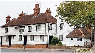
Turn left when exiting Eynsford station and walk down to the junction with the main road. Turn right and walk into the village centre, passing the Malt Shovel pub and St Michael's church on your right. Carry on past the war memorial. You will come to a shop on the left with a cottage attached (next to the baptist church). Eynsford seems a sedate enough place now, but the peace of the village was disturbed in the late 1920s when two hell-raising composers, EJ Moeran and Peter Warlock, moved into this cottage (see panel below). They are commemorated on a blue plaque.
After the turning for Sparepenny Lane, follow the bend of the road around. The field on your left is home to rare-breed, long-horned cattle. You will soon come to a footpath sign pointing to a path forking off and up to the right. This heads diagonally across a field, from which you can see the Eynsford Viaduct, which was constructed in 1859. Cross over the railway tracks and then follow the path across the next field, aiming for a gap in the hedge. The path briefly cuts across the corner of another field before emerging at a lane.

The building on your left is Lullingstone Roman Villa. Built around 100 AD, it is one of the best-preserved roman villas in the country. It is open daily (paid admission). From here, head back the way you came, passing the path where you emerged and continuing on the lane. After about half a mile, after a farm on your right, you will come to Lullingstone Castle, with its impressive gatehouse. The castle, built in 1497, is actually more of a manor house. It was visited by both Henry VIII and Queen Anne and its grounds include a 'world garden' of exotic plants. The house is privately-owned and only open on certain days (check here for details).
Carry on walking down the lane. Just beyond the gatehouse, there is a gate to a car park on your right. Enter the car park and carry on straight ahead through a swing gate, following the Darent Valley Path. This runs right alongside the river and can get very muddy (an alternative is to walk along the parallel path in the adjacent field). The path emerges at the Lullingstone Country Park visitor centre. The park is home to oak, hornbeam, beech, ash and chestnut trees, some of which are 800 years old. In the spring and summer months, the grassland areas have a variety of wild flowers, including orchids. For more about the park, including a map, go here.

Turn right. Shortly on the left you will come to a metal gate and a footpath sign. Take this path, which runs behind a house and passes under power cables, before turning due south at a farm, running between two fields. At the end of the field, there are some trees and a stile and dog gate. Follow the path downhill along the edge of a field, with trees on your left and a fence on your right, to Cockerhurst Road. Turn left and walk down the lane. After about 350m you come to a T-junction. Turn right onto Castle Farm Road. There is a curious memorial stone here, which bears the words 'Behold therefore I will allure her and will lead her into the Wilderness and there I will speak to her'. It also urges passers-by to pray for the souls of 'E G J B' and 'A J B'.

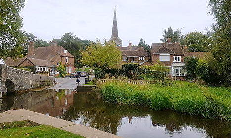
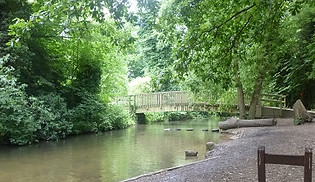
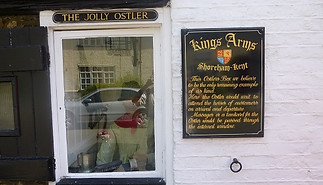
Continue down the High Street, before turning left into Church Street. Here you will find the Kings Arms on your right. Cross the bridge over the river and turn left up Darenth Way, with the river to your left. This becomes the Darenth Valley Path. You come to a footbridge on your left, with views of Queen Anne House. Rather than crossing the bridge, turn right and go through a gate. Then follow this path along bushes and past orchards and fields for 500m. The path skirts The Mount Vineyard, which has a restaurant, bar and shop, before meeting a track. Turn right and walk down to the parish church, going through a gate into the churchyard.
Take the stile on your right into Otford Recreation Park. This contains a scale-model of the solar system. Built as a Millennium project, eight of the planets are within the park, but for the others you need to go further afield (Uranus is by a bus stop). The Londonist has a guide on how to locate them all. Exit the park via the SE corner onto Park Lane, which leads down to the High Street. Turn right to reach The Bull pub, a 15th century inn which has a great beer garden and some historical artefacts associated with the nearby Bishop's Palace (there's another pub further down on the right, opposite Pickmoss, a grand half-timbered building).

On leaving the palace, head back the way you came and turn into the entrance of St Bartholomew's church, the oldest parts of which date from the 11th century. To get to the station from here, take the path that skirts around the right-hand side of the church and then follow it through a graveyard which has a brick wall on your left. At the end of the graveyard, go through the wooden gate and continue along the path ahead. This leads directly to Otford station. Trains run late from here back to London.
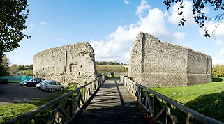
Retrace your steps and take the lane opposite the Castle Hotel. It leads to the ruins of Eynsford Castle, one of the most complete Norman castles in the country, unusually protected by an exterior wall. If you want to explore the ruins, it opens at 10am every day. Leave the way you came and head back down towards the church, turning right opposite its entrance into Riverside. Cross the bridge over the River Darent, which often floods here and becomes a ford. Walk along the green that runs alongside the river and carry on along Riverside, passing the Plough Inn.

Turn right here for the Eagle Heights wildlife centre, home to birds of prey, alpacas and camels. There are two bird displays every day – check here for details. If you're not interested in visiting the centre, just continue along the clearly-defined path on the other side of the lane from where you emerged (you can spot some of the animals by walking up to the fence on your right). Ignore the entrance to the field on your right, and continue in the same field, keeping a low hedge to your right. When you reach the end of the field and a line of trees, turn left. This path becomes a track through trees which emerges down some steps at a lane.

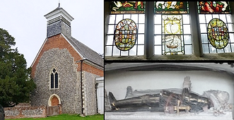
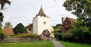
Next to the castle is St Botolph's Church. Originally built in the 1300s, it contains a medieval wooden screen created for Sir John Peche and decorated with Henry VIII's tudor rose and pomegranates, the symbol of Catherine of Aragon (Henry stayed here and a joust was held in the grounds in his honour). The church also features a number of striking tombs and effigies to the previous incumbents of the adjacent castle – including Sir Peche himself. There are also some beautiful stained-glass windows, some of which date from the 14th century. Read more about the church here.
From the visitor centre, head across the car park and follow the sign to the Discovery Trail. The path follows a line of trees to your right. After a bend, in the middle of the copse to your right, is Druids Picnic Spot. Like other parts of the park, it has some interesting wooden sculptures. Return to the path. Where the trees end, the Discovery Trail heads diagonally across the field in a SW direction and enters Lower Beechen Wood. After about 100m, turn left down a track. When you reach the edge of the wood, turn right (following the Lullingstone Loop/Woodland Walk trails). You will come to a small strip of clearing on the right. Turn left, follow the track and go over a stile on to Redmans Lane.

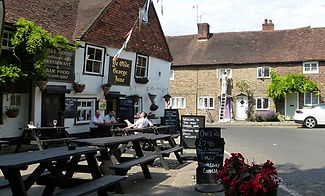
You will very shortly come to another junction. Turn left here and follow the lane into Shoreham. This is one of Kent's best-kept villages and its worth taking some time to explore it. We suggest heading down the lane, which becomes the High Street. On your left is the Crown pub (Shoreham has two others, also worth visiting). Further down, on the right, just past the village hall, is the turning to Shoreham Aircraft Museum and the Oak Bakery Tearoom. In September 1940, the Battle of Britain took place in the skies above Shoreham and the surrounding area. A German bomber was shot down and landed in a nearby field, before its pilot was captured. Check the museum website for opening times.
Leave the church via the lychgate on the other side. Facing you is the Samuel Palmer pub, an old coaching inn. Turn left and walk down the road, passing the driveway to Shoreham Place. You will come to a green footpath sign on your right. Take the path, which runs across a golf course (follow the signs) and then, via a swing gate and stile, skirts the east side of a cricket pitch. The path leaves the cricket field via a gate into a small copse. When the path emerges at a lane, head straight across, following the bridleway as it runs between bushes and crosses the southern section of the golf course. When the track leaves the course, follow it between fields until you reach Park Farm livery stables on your left.

.
Turn right after leaving The Bull and head towards the roundabout which surrounds the village duck pond. Cross over towards the church, but take the path on the right following the sign to the Bishops Palace (also known as Otford Palace). The path passes Chantry Cottage on the left and a large Georgian house on the right before reaching the palace ruins. Originally dating from Saxon times, this was the former residence of a succession of Archbishops of Canterbury. It was rebuilt in 1515 to supposedly rival Hampton Court. Notable visitors and residents included Thomas Beckett, Henry VIII and Thomas Cranmer.
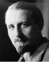
From 1925-28, the composers EJ Moeran and Peter Warlock lived in a cottage in Eynsford which became a focus for their hedonistic lifestyles. Moeran, whose work was heavily influenced by English and Irish folk music, had attracted acclaim as a promising young composer when he met songwriter and critic Peter Warlock in the early 1920s. Warlock (the pseudonym of Philip Heseltine – he changed his name because of his fascination with the occult), cut a strikingly handsome and flamboyant figure. A friend of WB Yeats (as well as other literary figures), he shared Moeran's interest in Celtic culture and language. The two became close companions and decided to rent the Eynsford cottage together with the artist Hal Collins. It attracted visitors from the worlds of art and music and their wild drunken parties scandalised the locals with rumours of orgies and related debauchery. Warlock also had a habit of riding his motorbike naked through the village, while Moeran upset worshippers at the baptist church next door by singing loud Irish sea shanties.
Although their way of life didn't seem to affect Warlock's creative abilities, Moeran almost stopped writing altogether – the exception (unsurprisingly perhaps) being a drinking song called Maltworms, a joint composition with Warlock written for a drama festival in Shoreham (although its only performance was in a local pub). Moeran left Eynsford in 1928, and by 1930 Warlock was dead (possibly by his own hand). Moeran was devastated by his friend's death, saying: 'His loss will mean a terrible gap to me when I get back to normal life and find he is no longer there'. With his drinking companion departed, Moeran managed to re-establish his reputation with a series of well-received works in the 1930s. Warlock had seemingly foreseen his own demise, writing an epitaph for himself while living in Eynsford: 'Here lies Warlock the composer/ Who lived next door to Munn the grocer/ He died of drink and copulation/ A sad discredit to the nation'. KB

Walks by County
Listed by the most traversed
county for each route
Berkshire
Buckinghamshire
Henley circular
Pr. Risborough-Wendover
Tring circular
Tring-Leighton Buzzard
Cambridgeshire
Cambridge-Trumpington
Whittlesford-Wandlebury
Derbyshire
Edale-Hope
Dorset
Corfe Castle-W. Matravers
East Sussex
Ashdown Forest
Berwick circular
Berwick-Seaford
Cuckmere Haven-E'bourne
Forest Row-Eridge
Glynde-Berwick
Glynde-Seven Sisters
Isfield-Lewes
Lewes circular 1
Lewes circular 2
Lewes-Hassocks
Lewes-Rottingdean
Plumpton-Hassocks
Rye-Three Oaks
Gloucestershire
Kingham circular
Toddington-Cleeve Hill
Hertfordshire
Codicote-St Albans
Odsey-Royston
Kent
Oxfordshire
Surrey
West Sussex
Bramber-Amberley
Steyning circular
West Yorkshire
Haworth-Hebden Bridge
Wiltshire
Avebury circular