

Full-day country walks in
SE England and beyond
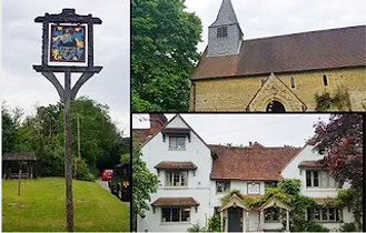
Gomshall circular via Leith Hill
Click on the image below to access
the full map on plotaroute
Distance: 14.5 or 10.3 miles.
Time without long breaks: 7 1/2 hrs (long) / 5 1/2 hours (short).
Terrain: A few mostly gentle hills and a lot of woods (can be muddy).
How to get there and back: Train to Gomshall. Bus back from Holmbury St Mary to Dorking or train from Gomshall (various options - see below).
Pubs: Sadly, the Stephan Langton in Friday Street recently closed. We're hoping it will reopen soon. Other pubs: The Wooton Hatch and the Royal Oak (at Holmbury, where the shorter walk ends). The longer walk includes the Abinger Hatch and ends at Gomshall, which has the Compasses.
More information: Gomshall station is on the line between Guildford and Dorking Deepdene. Catch a train to Guildford, Redhill or Dorking mainline (Deepdene is 3 mins walk). For the shorter walk, you have to go back via Dorking, so buy a return to there. If the connections aren't good, catch a No 32 bus from Dorking to Abinger Hammer or a No 22 to Paddington Farm. At the time of writing, the last bus from Holmbury to Dorking is at about 5.40pm (weekdays). Trains from Gomshall run until late evening.

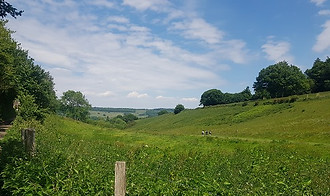
This quiet walk through the beautiful wooded Surrey Hills takes you to Leith Hill and its tower, which offers commanding views of the surrounding countryside. The shorter version ends at the picturesque village of Holmbury St Mary and the Royal Oak pub. Alternatively, you can carry on for another four miles back to Gomshall via Abinger Hatch. To make the most of the views from the tower, we suggest doing this walk on a bright autumnal day. Check the National Trust website for opening times.
Exit Gomshall station from platform 2 and follow the path to the road. Cross over, turn right and then left into Wonham Way, just before the bridge. Keep on the lane,which crosses over the River Tillingbourne before bending left. It then turns sharply right. Rather than follow the lane past the houses, turn left following the bridleway past Southbrook Farm (ignore the footpath coming off to the right). This crosses the river again before merging with Rad Lane and coming out at the A25. Turn right along the road to reach Abinger Hammer with its Victorian clock and bell tower. It depicts 'Jack the Blacksmith' (the area was once a centre of the iron industry), who strikes the bell with his hammer on the hour. The village was also home to the novelist E.M. Forster (see panel).

Carry on along the broad mud track via some more gates. When you reach the second clearing, go straight ahead aiming for a gap in the trees. Carry on along the track through the deciduous woodland of Abinger Rough nature reserve, with a field to the left (ignore the track that forks off right). When you reach the clearing at Leasers Barn, there is a stone cross monument to Samuel Wilberforce, Bishop of Winchester and grandson of William Wilberforce. Samuel died at that spot after being thrown from his horse. Carry on along the track until it emerges at White Down Lane. Cross over the lane and follow the bridleway sign.
Leave the church by the lattice front gate and go down the lane, which has great views to the left and behind, until you reach the main road. Cross over to the Wotton Hatch pub, the first opportunity for a refreshment break. Then head down Damphurst Lane, passing a red post box on your right. You will come to a turning to a business park on the left. Instead of carrying on down the lane, follow the footpath sign and take the path here that runs parallel to the road. This comes out at another wooden signpost and a house, Tillingbourne Lodge. Go straight ahead past the house, ignoring the private drive on the right, to join the Greensand Way long distance footpath via a metal gate.
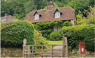
Just beyond 17th-century Old Cottage on the right, you will see a footpath sign. Take the path, which runs past the side of a modern house. Turn right at the post to follow the path around the back of it. When you reach a fence on the right, turn left up a rocky path. A path merges from the right and just beyond this you reach a lane by a junction. Cross over, take the path straight ahead and also cross over the next lane. Then take the path as indicated on the sign by the wooden railings opposite. Carry on along this path, ignoring the National Trust sign on your right, heading downhill. After about 400m, you will emerge at a lane by a large mill pond.
Turn left and walk down to the road junction. Take the left-hand fork by the red post box and head down the lane. Another lane merges from the left. Carry on straight ahead, following the footpath sign. After passing Sewers Farm on your right, take the footpath on the left by a metal gate, as indicated by the sign. Proceed past some chicken coops and follow a metal footpath sign past the front of a house. The path then turns left along the side of a house and enters a field via a metal swing gate. Follow the path around the top and then down the side of the field. Then turn left onto a path that runs along a fence past Leyland Farm. This emerges via a wooden gate by a footpath sign onto Sheephouse Lane.

On leaving the tower, take the prominent track that runs west. You are now back on the Greensand Way. After about 1/2 mile, it reaches Leith Hill Road. Turn right into the lane and then left into a car lay-by and follow the track which leaves the car park from the bottom left corner. After about 150m, take the track that forks off to the right opposite a farm gate. In 250m this merges with another track by a post. Turn right and then in 100m turn left following the waymarkers for the Greensand Way and High Ashes Farm. The path skirts the farm before entering the woods. Follow this clear path for about 3/4 mile. The bridleway eventually emerges by a bend on Pasture Wood Road, on the edge of Holmbury St Mary.

If you are doing the longer walk, the next pub is only about a mile away. On exiting the Royal Oak, head down Horsham Road in front of you. After 500m, enter the lay-by on the right and walk up the track. You will see a sign to the entrance to the wood. Don't go through the gate. Instead, turn sharp left past the wooden farm gate, with tall scots pine trees on your right. It's best to follow the directions here rather than try and follow the maps. The track goes past the backs of some houses then swings right by a clearing on the left. A little further up there is a fork of tracks. Rather than following the track round to the right, take the left-hand track ahead. After about 150m you will reach a footpath post. Take this path, that bears left and goes uphill to reach a stile into a field.
Go through the wooden gate and follow the track that runs along the edge of the field, ignoring the path on the right. When you reach Raikes Farm, keep the barns to your right. Ignore the sign on the left, but instead follow the track as it turns sharp right between houses. Then head down the side of Stable Cottage on the left to reach a wooden gate onto a lane. Turn right and a few meters down past the turning, just before a pair of wooden farm gates, take the footpath into the field. After 400m, a bridleway joins from the south by a sign. Carry on straight ahead until 100m on, by another sign, the paths diverge. Rather than continue on the bridleway which runs between hedges, turn off along a path that goes alongside a fence. This enters another field. With a house in the distance, head downhill towards a copse.

Turn left to reach Wonham Way and then right following the lane around the bend, retracing your steps from earlier in the day. At the next bend, however, turn off left at the sign to join a bridleway. After about 300m this passes some farm buildings on the left and a large house on the right to emerge at a lane. Go under the brick railway arch to reach Gomshall village. Turn right by the half-timbered house on to Goose Green. In a short distance on your right you will come to the Compasses pub (the Gomshall Mill opposite is another pub that has unfortunately closed). The station is about 500m (apx six minutes' walk) from here. Turn right and head down the main road and then left into Station Approach.

Carry on along the road through the village, passing the green on the right hand side which flanks the river. Just past the turning to Felday Road, you will come to a sign for Kingfisher Farm Shop (a good place to stock up on supplies). On the other side of the road to the turning for the shop and pond, there is a small car park with a gate leading to an uphill path. Take this path, which goes past some houses and runs parallel to the road. It emerges at a bus stop lay-by (this is the Paddington Farm stop mentioned above). Take a left turn here onto the bridleway. This holloway bordered by trees heads uphill before entering a scenic area called Broomy Downs via a wooden gate.

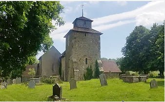
Follow the track with Dearleap Wood on your right and open fields on the left with views of the valley and the hills beyond. Approaching Park Farm, you will pass a collection of old barns. Just beyond these there is a junction of tracks. Ignore the track that turns right leading to the woods. Instead, take the footpath that heads diagonally through the next field into the woods via a gate. Follow the path uphill through the trees and then across fields with a fence on either side, crossing over the stile on the left to reach isolated Wotton Church. This Saxon church, dedicated to St John the Evangelist, has an unusual design and is best known for being the burial place of the writer and diarist John Evelyn, who was born in Wotton village.
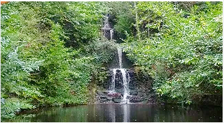
Keep on the Greensand Way, with a fenced-off field on your left, passing a stile and a wooden fingerpost on your right. The track heads downhill in a sunken lane between the trees. After about half a mile, you pass Stable Copse and a pond. Keep on going along the track, passing a house called Mandrakes on your left, with water meadows on your right. Shortly past the house you will come to a picturesque waterfall known as Tillingbourne Falls. After here, follow the track as it bends round to the right and over the stream towards the small hamlet of Broadmoor. The Greensand Way turns off left here. Instead, take the lane into the village.

Take the lane that runs along the top edge of the pond, with a wall on your right, and then turn left and head down the side of the pond towards the hamlet of Friday Street (keep on the lane, ignoring the gravel path on the left). You will soon come to the site of the sadly currently closed Stephan Langton pub. The pub was named after a local man who became the Archbishop of Canterbury in the 13th century. The track continues after the pub, entering the woods proper past a house called Lane End, and running alongside a brook. Around half a mile further on, the path emerges out of the woods by a house on Abinger Common Lane.
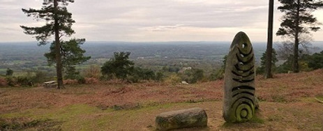
Turn right down the lane. After 200m, at a bend, you will see a wooden sign by a gateway to Wotton Common. Enter the wood here and proceed straight ahead along the broad track. Keep on the bridleway, until you reach a T-junction with two tracks crossing right to left. This is a spot where it is easy to get lost (there really should be better signage here). You need to ignore the tracks but keep on the footpath that zig-zags straight ahead. You should soon reach a clearing and Leith Hill Tower. Leith Hill is a National Trust site and the highest point in south east England. From the top of the gothic tower, it's possible to see 14 counties on a clear day and as far as the Palace of Westminster and the English Channel. There is a cafe here when the tower is open.

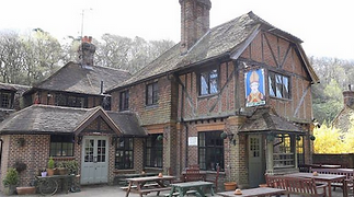
It's worth taking some time to explore this beautiful village, which was the basis for the fictional village of Summer Street in E.M. Forster's A Room with a View (see below). Turn left when you emerge at the lane and walk towards the road junction. Then take a right and then a left into Pitland Street. Just after a white house on your right, opposite a brick wall, turn right. This will take you past another sadly closed pub, the King's Head. Follow the lane past the houses. It comes out at the village green and pond. Turn left and follow the road around to the church. The church is located next to the Royal Oak pub, outside of which is a bus stop. If you are doing the shorter version of the walk, it ends here.

Cut across the field, following the clear path and aiming for the stile on the other side. Go over the stile and down the steps onto a lane. Cross over the lane and go through a gap in the hedge to reach Abinger Common village green, which contains a war memorial designed by Edwin Lutyens. Cut across the green and turn right to reach the Abinger Hatch pub, a lovely country inn. It's worth having another breather here before you embark on the final stretch. On leaving the pub, head back across the road and go through the lychgate to the church, parts of which date from the 12th century. Walk along the left-hand side and exit via the gate at the rear. Then follow the path around, with Abinger Manor and a motte (site of an old castle or fort) on your left.

Cross over some stiles and a footbridge over a stream to emerge at Felday Road. Cross over the road to the track opposite and head up the path straight ahead by the fingerpost. Follow the path round to the right as it skirts around the grounds of a house. Then turn sharp left by a stile and follow the path across a field. When you reach the other side, turn right and follow the path along the line of trees. After about 150m, look out for a stile on the left to join a bridleway running north-south. Turn right and then after a few meters turn left off the bridleway onto a footpath that crosses diagonally across a field to the far corner of some houses. You emerge at a farm driveway. You are now back at the spot where you were many hours ago.

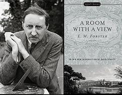
By the time E M Forster moved with his mother to West Hackhurst in Abinger Hammer in 1924 he had already completed all of his novels. Despite living to his nineties, his final novel, and greatest success, A Passage to India, was published when Forster was 45, in the same year he moved to the village. He had inherited the house from his aunt, whom he had visited frequently, and was already well-acquainted with the surrounding countryside. The area had provided some rich material for Forster in his depictions of Edwardian class divisions. He'd based the village of Summer Street in his 1908 novel A Room with a View on Holmbury St Mary and the village contains many sites, such as the church and the pond, that are featured in the book (although the village locations for the Merchant Ivory film version were shot in Kent).
Forster named a collection of essays Abinger Harvest and his love for the area was also evident in two pageants he wrote. Abinger Pageant, which featured 500 local participants (see picture), told the history of the village and was also a homage to the diarist John Evelyn, who had lived at Wotton. Forster additionally wrote England's Pleasant Land, about protecting the countryside from developers. It was a theme that was close to his heart and he successfully campaigned to save a local wood. As a Cambridge-educated, slightly eccentric intellectual and socialist, the villagers were not sure how to take to Forster at first, especially given the rumours about his homosexuality (the writer at this time was in a complex relationship with a married police officer – a menage à trois that inspired the 2023 film My Policeman). But when he left Abinger in 1946 he was seen off with a grand party, the centrepiece of which was a speech by Forster on the importance of preserving footpaths. So perhaps we have him to thank for some of them on this walk. KB

Walks by County
Listed by the most traversed
county for each route
Berkshire
Buckinghamshire
Henley circular
Pr. Risborough-Wendover
Tring circular
Tring-Leighton Buzzard
Cambridgeshire
Cambridge-Trumpington
Whittlesford-Wandlebury
Derbyshire
Edale-Hope
Dorset
Corfe Castle-W. Matravers
East Sussex
Ashdown Forest
Berwick circular
Berwick-Seaford
Cuckmere Haven-E'bourne
Forest Row-Eridge
Glynde-Berwick
Glynde-Seven Sisters
Isfield-Lewes
Lewes circular 1
Lewes circular 2
Lewes-Hassocks
Lewes-Rottingdean
Plumpton-Hassocks
Rye-Three Oaks
Gloucestershire
Kingham circular
Toddington-Cleeve Hill
Hertfordshire
Codicote-St Albans
Odsey-Royston
Kent
Oxfordshire
Surrey
West Sussex
Bramber-Amberley
Steyning circular
West Yorkshire
Haworth-Hebden Bridge
Wiltshire
Avebury circular