

Full-day country walks in
SE England and beyond
Odsey to Royston
Distance: 9.3 miles.
Time without long breaks: 5 hours.
Terrain: A few hills, nothing too steep.
How to get there and back: Train to Ashwell and Morden station, return from Royston. Trains go from Kings Cross or St Pancras (catch the stopping service to Cambridge).
Pub breaks: The Fox & Duck, Therfield, is almost halfway through the walk so ideal for a break. At the time of writing, it is closed on Mondays and Tuesdays. Otherwise, you will have to wait until you reach Royston, which has a quirky pub in an old post office called The Jolly Postie.
More information: This is a good walk to combine with a visit or night out in Cambridge, as Royston is only a few stops away on the train. If you want to visit Royston Cave (see panel below), you will need to check opening times. It is currently only open at weekends or bank holidays between Easter and October.

Click on the image below to access the full map on plotaroute

Traversing gently undulating downland, this walk straddles the Hertfordshire/Cambridgeshire border and includes the nature reserve at Therfield Heath, which has some remnants of prehistoric civilisation and far-reaching views of the surrounding countryside. You also pass through the sleepy villages of Kelshall and Therfield, the latter with a handily-placed pub on its village green. The walk ends at Royston, which has a fascinating medieval cave that is occasionally open to visitors.
Turn left when you exit the approach road to Ashwell & Morden station (the station is 1 1/2 away from Ashwell and is located in the hamlet of Odsey). Proceed over the bridge to the junction with the A505. Cross over and take the path opposite, continuing in the same direction through the fields uphill. This path is called Chain Walk and takes you to the top of Gallows Hill (the hill to the right, incidentally, is called Deadman's Hill). There is a tumulus and a small concrete building, possibly a pill box, here. The path then runs downhill to Heath Farm. Don't make the mistake we did and turn into the farmyard, but carry on until you meet the lane.

This path initially runs alongside some trees and then cuts across the middle of the field. When you enter the next field, you may see a large fallen tree on your right. Go past the tree and through some wooden gates. Cross over the lane by some buildings and follow the path through a horse paddock by a bungalow. You emerge opposite the village hall and a red phone box (now acting as a book depository) at the centre of the small village of Kelshall, best known for the Kelshall Hoard, a recent discovery of Roman artefacts.

Leave the churchyard by the top right exit and follow a path that runs between walls past the old rectory and its grounds. This track takes you back to The Street. Turn left and walk back to the traffic island where you were before and this time turn right. A few meters down, just past the first bend, you will spot a green footpath sign on your left. Take this path, which follows the edge of the field then cuts across the corner to enter another field (it can get muddy here). Head across this field in the same direction towards a swing gate, with Therfield Church tower in the distance.

When you reach the thatched house on the corner, take the track ahead which is the driveway to Grade II listed Bury Hall. As the driveway turns left towards the house, take the path to the right that then cuts across the field. The undulating ground here is the site of a motte and bailey, the remains of 12th-century Therfield Castle. The path emerges via a stile at a track, part of the Hertfordshire Way. Turn right and go past the water tower which is adjacent to a triangulation point. When you reach the road turn right, then after a short distance, opposite the houses, turn left at the footpath sign and go through the swing gate.

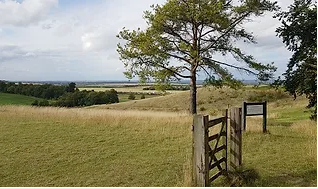
After about 100m you come to a stile on your left, with raised ground beyond. This is Church Hill, home to rare pasqual flowers, which bloom in early spring. You have a choice here – you can either cross over the stile and go across the mounds (following the route of the Herts Way). Alternatively, carry on along the path as it skirts around, passing gates to a grassy meadow, and then turning left and north along the edge of the woods of Fox Covert nature reserve. Whichever route you take, you should soon come to a standalone wooden gate by a tree with panoramic views of the valley below. A good place to take some time out.
Turn right along the road. Just past the Jolly Postie pub there is a boulder which once formed the base stone of Rosia's Cross (named after Lady Roisia, the wife of William the Conqueror, who gives her name to Royston). The cross marked the meeting point of the Icknield Way (see walk 9) and Ermine Street. Over the other side of the junction, on Melbourn Street, is Royston Cave (see panel). This enigma was discovered in the 18th century. You need to book a tour to view it and it's only open at weekends and on bank holidays in spring and summer (more information here). Royston station is located about 10 mins walk from here (head down Kneesworth Street from the junction).
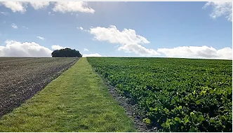
Turn left and follow this quiet lane with open fields on either side and expansive views. After just over a mile, you will come to a junction and a signpost at Stump Cross. Ignore the turning on the right, but bear left along the lane, in the direction of Therfield, as indicated on the sign. After 400m you will come to a junction with Coombe Road. Just beyond this there is a green footpath sign on your right. Take this path (you are still on Chain Walk) which runs along the edge of a field. When the path reaches the corner, rather than follow it round, take the path that turns off to the left.
Walk down to the traffic island on your right, which contains the remains of the old village cross and a new millennium monument with some panels about the village's history. Take the right-hand fork past the house and the next left hand fork a few meters further on (following the sign that says 'Church only'). Follow the road around until you reach the front entrance to the church, dedicated to St Faith. There is another old medieval cross in the churchyard, in a better state of repair than the one in the centre of the village.

Follow the path diagonally across a further field. On exiting, turn right along a grassy track towards Therfield Church on your left. The original 13th-centuy church was rebuilt in Victorian times. For many years the bells in the tower were not used and a bell which hung from a nearby tree was used instead. Continue along Church Lane, which has some beautiful old thatched houses, to the village green, which is overlooked by the Fox & Duck pub (there are tables on the green in the summer). From the pub, cross back over the green and head down Pedlars Lane opposite.

Follow the Hertfordshire Way as it heads downhill through Slipes Wood before emerging at open countryside. After about 1 1/2 miles along the track you come to Thrift Farm. Walk through the farm buildings and then turn sharp right, still on the Herts Way. Walk along the top edge of the horse gallops, parallel to the road and the railway line below and with racing stables to your right. After about 3/4 mile follow the path as it veers right along a line of trees to join a track heading south, with Pen Hills to your left.
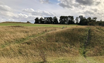
Continue on the Hertfordshire Way through Jubilee Wood. When you come to a road, cross over and carry on along the path opposite following the waymarkers. This emerges at Therfield Heath, where prehistoric burial mounds (including a Neolithic long barrow) share the space with a golf course (look out for flying golf balls). The heath is a nature reserve and Site of Special Scientific Interest, home to species such as the chalkhill butterfly. Follow the path as it passes the long barrow and tumuli and cuts across the golf course. There are views of the countryside, the Royston suburbs and an industrial site to your left. The path heads downhill and crosses the Icknield Way Trail before joining the road.
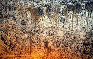

When devising these walks we would often discover fascinating local features in seemingly unpromising locations – proving the old adage that there is treasure everywhere if you look hard enough. Royston's treasure is its remarkable medieval cave, which was discovered by workmen in 1742. Initial explorations of the cave unearthed a skull and some pottery fragments and revealed spaces apparently set aside for prayer and initiation ceremonies. The most striking feature to be uncovered were its wall carvings, which depict various Christian saints. One, thought to be St George, holds a sword pointing to thirteen figures, believed to be Christ and the disciples. There’s a panel that depicts the resurrection and two crucifixion scenes. To the left of one of these is a possible memorial to the Grand Master of the Knights Templar, Jacques de Molay. There are also some non-Christian carvings, including a sheela na gig and an earth goddess. Other figures, such as one holding a skull and a candle, remain unidentified. Studies of the designs indicate the carvings were probably created in the mid-1300s.
The purpose of the cave remains unknown. Built at the crossroads of two trading routes, it was possibly a hermitage visited by travellers in need of spiritual sustenance. There is also speculation that it was Lady Roisia's private chapel. Believers in ley lines point out that the Michael and Mary lines, which pass through Glastonbury and Avebury, cross at the site, bestowing on it a powerful mystical energy. One popular theory is that it was created by the Knights Templar, who had a strong presence in the local area. This is supported by the fact the carvings are similar to those found in Templar sites in other parts of Europe. The Templar were an influential religious and military order who took part in the Crusades and became vastly wealthy. They went underground in the early 1300s after being declared heretics by the Pope and threatened with being burnt at the stake. It is possible the Royston cave was one of their secret places of worship. KB

Walks by County
Listed by the most traversed
county for each route
Berkshire
Buckinghamshire
Henley circular
Pr. Risborough-Wendover
Tring circular
Tring-Leighton Buzzard
Cambridgeshire
Cambridge-Trumpington
Whittlesford-Wandlebury
Derbyshire
Edale-Hope
Dorset
Corfe Castle-W. Matravers
East Sussex
Ashdown Forest
Berwick circular
Berwick-Seaford
Cuckmere Haven-E'bourne
Forest Row-Eridge
Glynde-Berwick
Glynde-Seven Sisters
Isfield-Lewes
Lewes circular 1
Lewes circular 2
Lewes-Hassocks
Lewes-Rottingdean
Plumpton-Hassocks
Rye-Three Oaks
Gloucestershire
Kingham circular
Toddington-Cleeve Hill
Hertfordshire
Codicote-St Albans
Odsey-Royston
Kent
Oxfordshire
Surrey
West Sussex
Bramber-Amberley
Steyning circular
West Yorkshire
Haworth-Hebden Bridge
Wiltshire
Avebury circular