

Full-day country walks in
SE England and beyond
Rye to Ickesham and Three Oaks
Distance: 11.6 (long) or 6.9 miles (short).
Time without long breaks: Walking time apx 6 hours (long), 3 1/2 hours (short), but add extra for exploring Rye and Winchelsea and pubs.
Terrain: Mostly very flat, one moderately steep hill.
How to get there and back: Catch a train from London St Pancras to Rye, changing at Ashford International. If doing the longer route, return from Three Oaks which is on the same line (buy a return ticket to there). Trains also run from Three Oaks to nearby Hastings. If doing the shorter route ending at Icklesham, catch the No 100 bus back to Rye and then the train (buy a return ticket to Rye).
Pub breaks: Rye's taverns include the famous Mermaid Inn, but it is at the start of the walk. Winchelsea has the New Inn, while Ickesham has the Queen's Head (just over halfway through the longer route and where the shorter route ends). Three Oaks has a pub a few minutes walk from the station. If you want to visit Hastings on the way back, we recommend the First In, Last Out and the Jenny Lind in the Old Town.
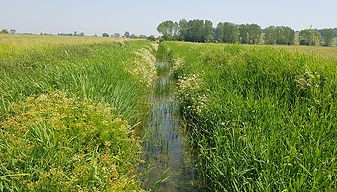
More information: Some of this walk is through marshland, so it's best avoided after a spell of wet weather or when it's likely to be foggy.

Click on the image below to access the full map on plotaroute

Starting in the smugglers haunt of Rye, famous its cobbled streets and old inns, this route mostly follows the 1066 Country Walk. It includes another of the 'antient' cinque ports, Winchelsea, a town with many literary connections and the resting place of the comedian Spike Milligan (see panel). Continuing via the marshes of Brede Level – populated largely by sheep (and lambs in the spring) – you reach the Queen's Head at Icklesham, where the shorter route ends. The longer walk then traverses a more typical Wealden landscape, past farmsteads and oast houses, to Three Oaks, which has a pub and a station.
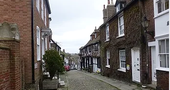
Rye is one of a number of port towns in this part of East Sussex and Kent to be a designated cinque port – a middle ages confederation of initially five towns (the 'antient' town of Rye was added to these, along with Winchelsea). The town's beautifuly-preserved streets and houses are well worth exploring and today it attracts many tourists. From the station, go straight ahead along Station Approach then at the junction (by the Cinque Ports pub) cross straight over into Market Road. Then take a right into the High Street and a left up West Street. This will take you past the top of Rye's most famous cobbled road, Mermaid Street.
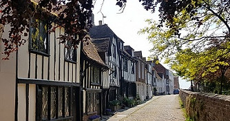
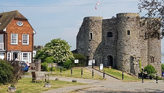
Continuing around the church, Church Square leads down to a fortification called Ypres Tower, which was built in 1259 to defend the town from the French. There are views towards the sea from the top of the tower, which houses a museum. The most striking exhibit is a replica of an iron gibbet cage containing the skull of murderer John Breads (the real grisly exhibit can still be seen – by appointment – in Rye Town Hall). Walk around the other side of the church on your way back. You will come to Watchbell Street, which has some more fine old buildings. But take a right to return to West Street and the top of Mermaid Street. Turn down here.

Cross over the zebra crossing and follow the road round past the roundabout. Go over another crossing to a sluice by a bridge. On the other side of the bridge, turn right down a track that runs parallel to the River Tillingham on your right, crossing over the railway line. On the other side of the river you will see Rye windmill. As the path enters a green open space, take a sharp left and follow the path along the line of trees into Gibbet Marsh. Cross a footbridge and continue along the path, which runs parallel to the railway line and a stream. Cross two more bridges. After the second one, the path turns sharp right. When it meets another track, turn left.

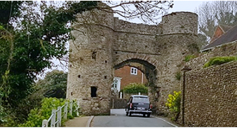
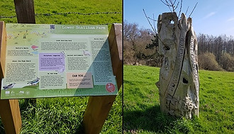
You soon reach the tiny station (a long way from the town), which unusually has an information board which fills you in on the wildlife of the Brede Valley (look out for water voles). About 1/2 mile further along the winding lane, you come to the hamlet of Ferry Bridge. Cross the bridge over the River Brede, ignoring the footpath sign. The lane soon meets a road junction by a hairpin bend. Turn left along the pavement past a caravan park. When you reach some houses and a junction, take care crossing over the road and go up the steps opposite. Head up the road to the Strand Gate, one of Winchelsea's surviving medieval gates.

The churchyard's most famous permanent resident is Spike Milligan (see panel). One of the houses on the road to the west of the church has a nice nod to Spike with a sign on the door saying 'Beware of the leopard'. A little further up, past the village sign, is the Court House, one of Winchelsea's oldest buildings. Its basement was once used as a jail. On the other side is the New Inn. To continue the walk, head down the side of the Court House into Hiham Green and then take a left at Mulberry Cottage down a small lane (Mill Road). When this meets the main road, cross over (you will see another of the town's old gates down to your right).

Rather than continue on the track that runs alongside the bank of trees to your right, take the path on the left that heads down a small slope into the marsh (alternatively, continue along the track and then turn left when you reach a signpost). It can be quite easy to get lost on the marsh, so best to follow the instructions below. The path leads to a small bridge (really just some planks) over a ditch. Cross over and then follow the path as it swings left in the next field, following some bushes and a ditch on your left. In 200m you cross another ditch by a small wooden gate with a footpath marker and metal railings and the river to your right.

Rather than following the path to the bridge that leads towards them, take a sharp left here down a path that leads to a smaller wooden bridge. Cross this bridge and then go over a stile to cross back over the railway line. On the other side, cross another stile and then follow the path as it heads straight down the fields following a ditch to your right. Proceed via a metal farm gate, passing a sheep wash. After about half a mile, just beyond a pair of gates, the path divides. Take the path on your right, which heads uphill. On non-misty days, there are great views of Brede Level below.

To continue on the longer route, turn right when leaving the pub and then follow the lane that runs past the backs of some houses. After the lane ends, the path skirts around a barn conversion. When you reach a signpost, turn right through a gate, following the sign for the 1066 Country Walk and passing an information board. The grassy track heads downhill. Aim for the telegraph pole at the bottom, and then go through a metal gate to cross over a bridge. In the next field, follow the telegraph poles, passing under electricity wires. Cross over a stile by a gate and then go through a metal gate and proceed past a house.

Follow this track past the houses and farm buildings, and then a modern barn on your right. Continue with a hedge on your right and views down towards the valley on your left until you reach a metal gate. Go through this and follow the track across a field. It bends left at the bottom to go past Lower Snailham Farm. Go over a stile by a signpost, following the route of the 1066 walk. Proceed past the old farmhouse and go through a gate on your left by a carved tree trunk. Head down the field, aiming for the bottom left corner. Go over the stile, turn right and follow the track. In 250m, you reach a signpost. Turn left and follow the path.

Proceed down this narrow country lane, taking care to look out for traffic. You pass the turning for Doleham station, one of the quietest stations on the rail network with only one or two trains a day. About 200m further on, you reach a bend. Go straight ahead through the gate next to a house called Ashenden, as indicated by the signpost. Follow the grassy track that runs past a small lake. The path descends towards trees. Go over the stile then cross over the railway track. Proceed over the stile on the other side. Walk down across the field and go over a bridge. The 1066 Country Walk goes in two directions. Turn left and walk along by the fence.

Cross the field ahead, following the grassy track. Go through the gate into the next one, then aim for a gap in the hedge. Follow the sign, going straight ahead rather than turning left. Pass a telegraph pole and cross a stream into another field and then head uphill to a gate. Just inside the next field, you will come to a signpost. Take the path on the right towards the houses. Go through a metal gate and then turn left to reach the Three Oaks pub. Three Oaks station, where you can catch trains to London, Rye and Hastings, is 150m from here (2 mins walk). Turn right as you leave the pub. To reach the only platform, take the gate on the left before the bridge.
You will walk down Mermaid Street later, but following West Street round will take you to St Mary's Church. If you walk down the path that runs to the left of the church to Lion Street, you will find Simon the Pieman, a good place to stock up on snacks. The church has an unusual clock (said to be one of the oldest working church clocks in the country). It features two gold cherubs known as the 'Quarter Boys', who chime the bell at quarter past the hour. The inscription above the clock reads 'Our time is but a shadow that passeth away.' You can climb the church tower.
On the right, you pass the allegedly haunted Mermaid Inn, a once popular hangout for notoriously violent smugglers the Hawkhurst Gang, who would brazenly place their guns on the inn's tables. The gang would use the surrounding marshes to smuggle their contraband and there is apparently a tunnel used by them that connects the Mermaid with Rye's oldest surviving pub, the Old Bell. At the bottom of Mermaid Street, there are two other pubs - the Old Borough Arms and The Ship, and the Old Grain Store cafe. Head straight ahead via The Deals to Strand Quay and the river and turn right at Rye Heritage Centre.

Proceed down the track, with a steep bank rising to your right and the marsh and railway line to your left. The path is a cycle route and also part of the 1066 Country Walk long-distance footpath, which forms large sections of this walk. After about a mile, the bank ends and you go through a gate by a cattle grid and pass a house on your right at a bend in a lane. This is Dumb Woman's Lane (supposedly named after a woman who had her tongue cut out after informing on smugglers). A house at the top of the lane was home to the comedian Spike Milligan (see below). Carry on in the same direction until you reach a road junction. Turn left, following the sign in the direction of Winchelsea station.
The present-day settlement was built in the 13th century to replace Old Winchelsea, which was nearer the sea and destroyed by a flood in 1287. Its charm has attracted a remarkable list of literary greats – Joseph Conrad, Ford Maddox Ford, Henry Irving and WM Thackeray were all sometime residents. The town is also where John Wesley held his last open-air sermon. Once you have passed the gate, head along the raised pavement. You soon reach the church on your left. Castle Street, on your right, has the Armoury and old town well. Cut across the churchyard. The church of St Thomas the Martyr was rebuilt in Victorian times, although ruins of the original building survive.

Carry on along Mill Road as it continues opposite. The lane runs past some houses and leads to a gate marked St Leonard's Church Field. This is where the old church used to stand. It is also the site of a windmill that was blown down in the Great Storm of 1987. The ruins of the mill are still there, by a beacon and a triangulation point. Walk down from here to reach a wooden gate marked Hanging Field. Go through the smaller gate and turn right along a path that runs downhill and swings around the banks to the right. In just over 150m, you will come to a marker post (pictured left) for the 1066 Country Walk by some wooden rails.
Carry on along a broad grassy track, which soon runs near a ditch to your left. When you reach a bridge with a gate to your left, don't cross over, but continue along the track. About 250m further on from here, you reach a small brick pumping station. Go through the gate and then follow the riverbank. After a while you will come to a metal farm gate and, beyond this, a stile. Cross over and go up the steps to reach a crossing over the railway line. Follow the path on the other side of the tracks and go over the stile. On your right you can see the small village of Cock Marling and its oast houses.

When you get to the top, the track passes some rocks and leads to a stile. Cross over to reach the Queens Head pub, on the edge of the village of Icklesham. The beer garden has views across the marshes towards Winchelsea. If you are carrying on to Three Oaks, this is a good place to rest and refuel as it is just over halfway through. If you are doing the shorter version of the walk, this is where it ends. The bus stop for buses back to Rye is five minutes' walk. From the pub, head straight down Parsonage Lane and turn right when you reach the main road. The stop is 200m from here. If you want to head to Hastings instead, the stop is on the other side of the road before this one.

Walk up the track towards the farm and oast houses ahead of you. As you approach the oast houses, you go past a house on your right. The footpath appears to have been diverted here, but only for for a very short distance. Take the track on the right as indicated.by the sign. Then go through a gate by a cattle grid and along a track that runs past the back of a barn. It then rejoins the marked footpath by the entrance to the oast houses. Follow the lane around the bend, passing the entrance to Brook Farm. When you reach a house on your right, turn right following the sign for the 1066 Country Walk and Snailham House.
When you enter the second field, keep on the path which bends to the right, cutting off the corner. and then follow the hedge. You will come to a post by a small tree indicating the direction of the 1066 Walk. Follow the arrow, which points to a wooden bridge (it was a bit flooded in this part when we last did this walk, so you may need to walk around the reeds to reach it). Proceed over the next wooden bridge ahead and then bear left following the path. Go through some trees to reach a small bridge over a stream and a stile into a field. When you get to the farm, follow the concrete track round. The farm drive comes out at a lane by a signpost. Turn right.

You follow a brook along the edge of this large field. Just before you reach the corner, follow the path as it turns left over a wooden bridge by a metal gate. Walk up the path by the side of the field, with the brook (Sailor's Stream) on your left. Continue via a gate into the next field and then follow the hedge which skirts the grounds of the house ahead. Take the gate on the right to go over a bridge towards a double-cowled oast house. Turn left at the sign opposite Great Maxfield, a large Elizabethan house. The track passes the house and leads to a gate. Go through this and then proceed via a gate on the left to go over a brick railway bridge.
The comedian, poet, writer and actor Spike Milligan moved to Udimore, near Rye, in 1988 and stayed there until his death in 2002. Most famous as a founder and key member of The Goon Show, he also created the surreal Q television series and wrote many books of prose and comedic verse, including Puckoon. His Udimore house, Carpenters Meadow, was described by Milligan as 'bloody awful' and 'the ugliest house in the world'. He rechristened it 'The Blind Architect'. His wife Shelagh revealed that Milligan had not paid much attention to the building when they bought it. The main reason for them moving to Dumb Woman's Lane was (aptly) the quiet and seclusion it offered, as Milligan's mental health and anxiety issues could often be tiggered by noise. Although he gave uninvited visitors short shrift, he was a popular local figure and was occasionally spotted by neighbours jogging down the lane in his carpet slippers.
Milligan's gravestone is in the form of a Celtic cross and is located by a small tree about halfway down the west side of Winchelsea churchyard. It bears his famous epitaph 'I told you I was ill'. However, it had to be inscribed in gaelic (Milligan was half-Irish) to comply with the demands of the po-faced officials at the Chichester Diocese. Milligan had been pleased to have outlived his good friend, fellow Goon and singer Harry Secombe. Commenting on Secombe's death in 2001, he said: 'I'm glad he died before me because I didn't want him to sing at my funeral'. Talking about his own passing, Milligan said he'd be pleased to go to heaven 'but if Jeffrey Archer was there, I'd make do with Lewisham'. KB


Walks by County
Listed by the most traversed
county for each route
Berkshire
Buckinghamshire
Henley circular
Pr. Risborough-Wendover
Tring circular
Tring-Leighton Buzzard
Cambridgeshire
Cambridge-Trumpington
Whittlesford-Wandlebury
Derbyshire
Edale-Hope
Dorset
Corfe Castle-W. Matravers
East Sussex
Ashdown Forest
Berwick circular
Berwick-Seaford
Cuckmere Haven-E'bourne
Forest Row-Eridge
Glynde-Berwick
Glynde-Seven Sisters
Isfield-Lewes
Lewes circular 1
Lewes circular 2
Lewes-Hassocks
Lewes-Rottingdean
Plumpton-Hassocks
Rye-Three Oaks
Gloucestershire
Kingham circular
Toddington-Cleeve Hill
Hertfordshire
Codicote-St Albans
Odsey-Royston
Kent
Oxfordshire
Surrey
West Sussex
Bramber-Amberley
Steyning circular
West Yorkshire
Haworth-Hebden Bridge
Wiltshire
Avebury circular