

Full-day country walks in
SE England and beyond
Salisbury to Stonehenge
Click on the image below to access
the full map on plotaroute
Distance: 13.9 / 15.1 miles.
Time without long breaks: 7 1/2 / 8 hours walking (the longer route is a diversion to a pub – see below).
Terrain: A few small hills. One gate you may need to climb over.
How to get there and back: Buy a return train ticket to Salisbury. To get back to Salisbury from Stonehenge, catch an X4 bus from Larkhill, about a mile to the north (buses run late weekdays and Saturdays).
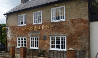
Pubs: There is an optional diversion (1 1/4 miles), to the Wheatsheaf in Lower Woodford, the only pub on the route. We recommend the Haunch of Venison in Salisbury if you have time for a drink before the journey home.
More information: Add a bit more time if you want to explore Salisbury Cathedral at the start of the walk. It is unlikely you will reach Stonehenge when the stone circle is still open to visitors, but if you do it might be possible to catch a tourist bus back to Salisbury. Salisbury Reds, which also runs the X4 from Larkhill, runs one of the services.

This walk links two magnificent ancient monuments – the iron age hill fort and abandoned settlement of Old Sarum and England's most famous Neolithic stone circle, Stonehenge. Beginning in the historic city of Salisbury, the route includes a visit to its cathedral, famed for its iconic spire. Here you can view one of the surviving copies of the Magna Carta. You then follow the River Avon to the original site of the city (Old Sarum). Continuing along the valley of the river, you cross it at Durnford Mill before heading north, passing clusters of burial mounds until Stonehenge becomes visible in the distance. Skirting the henge and crossing the cursus will take you to Larkhill, which has regular buses back to Salisbury.
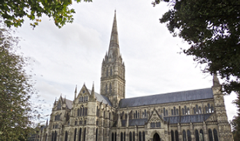
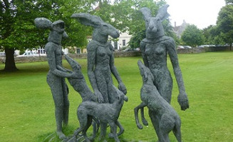
Turn left as you leave the station, heading down South Western Road, and then take a right into Fisherton Street at the junction by the railway bridge. After 150m, turn right along Water Lane which runs alongside a canal with houses on one side. At the bottom, turn left into Crane Bridge Road. After you cross over the river into Crane Street, you will pass some beautiful old houses. When you reach the junction, turn right into the High Street and pass through the old City Gate to reach Salisbury Cathedral Close. Former Prime Minister Edward Heath lived in one of the houses overlooking the impressive cathedral green, which is often used to exhibit sculptures and other outdoor artworks.
From the cathedral, head back down the High Street and through the City Gate. Head straight across at the junction and proceed past the shops until you reach Bridge Street. Turn left and when you get to the Kings Head, turn right and cross the pedestrian bridge to the other side of the river. The route follows the riverside path – initially along the Maltings, and then under a railway and a road bridge. It then crosses Ashley Road, before skirting a recreation ground and going past allotments to reach open fields on the edge of the city, following the course of the Pewsey Avon Trail. You will soon reach a bridge on your right at Stratford Mill. Cross over the river and proceed down Mill Lane until you reach a road.

Although you have to pay to enter Old Sarum's castle ruins (see the link above for details), you can wander around the rest of this evocative site for free. There are views towards Salisbury Cathedral from the tops of the banks. Leave via the main exit, which is on the eastern side. Passing the on-site car park, follow the driveway around to the left. When it reaches a bend that turns right by a farmyard, go through the small wooden gate on the left and then through another small gate. The track runs alongside bushes on your right and then emerges at a lane. Cross over and continue along the straight track that cuts across the flat fields of the river valley. You pass a house at Shepherd's Corner.

To take the detour. Turn left and follow Monarch's Way through the trees and then along the side of a field. You reach Salterton Farm and a road. Turn left down the lane and then right down a track by a red post box and a T-junction sign. The path crosses the River Avon and a tributary via two footbridges before reaching Lower Woodford. Turn left and walk through the village to reach the Wheatsheaf. Head back the way you came, but when you get to the farm turn right and take the track that runs between the farm buildings. The path bends sharp right and in a short distance meets a crossroads of tracks. Turn left, heading northwards.
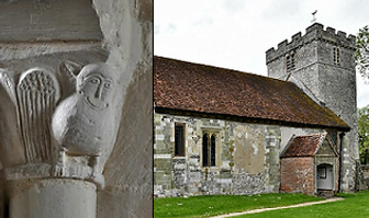
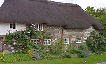
The church has many interesting features – look out for the 'doom painting' and the 'grotesques' of an owl and a dove. Head back to the road and turn right. You pass some thatched houses and the now sadly closed Black Horse pub. Two houses further on, you will see a track leading off to the right. This becomes a poplar-lined drive that leads to Durnford Mill. Cross the river by the sluices and then go over another footbridge. When you reach the other side, turn right. The path runs along the edge of a field and behind a house before crossing its driveway and continuing along the edge of the next field. It emerges at a road next to a thatched house. Cross over and go over the stile on the right, following the path as it runs parallel to the lane.
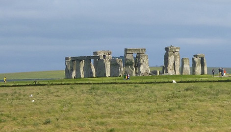
Instead of going straight ahead towards the stones, turn left across the top of the field (you may need to climb a gate) and join another byway that runs down towards the road. Cross over and continue along the track to the left of the monument. You can get a good view of the stones, first brought here 5,000 years ago. You probably won't have time for a full visit, but the visitor centre is just over a mile to your west, along the old public road. To reach the bus stop for the journey home, continue along the byway, which crosses the cursus and then runs through a plantation. Carry on until you pass some houses on the edge of the army town of Larkhill. When you reach a crossroads, turn right down Bingham Road. The bus stop is on your left, opposite Heath Square.
Salisbury Cathedral has the tallest spire of any building in England and it towers over the surrounding landscape. Work on building the cathedral started in the early 13th century after the original cathedral at Old Sarum was abandoned. The new site was supposedly chosen by shooting an arrow from the old cathedral. According to one version of the legend, the arrow struck a white dear which continued to run and died on the chosen spot. It took 38 years to construct the main building and the spire was added years later. The present cathedral contains one of four surviving copies of the Magna Carter. It also houses the world's oldest mechanical clock. You may spot some peregrine falcons, who have made their home in the tower, circling overhead.

Turn right. Just after a thatched cottage opposite a house, take the track on the left. After 1/4 mile, you meet a junction of paths. Turn left and then in about 100m take the track uphill on the right. This meets a path that skirts the outer banks of Old Sarum. Turn left and follow it until you reach an entrance track. Old Sarum is one of the country's great historical sites. A fort was established here around 400 BC. It was taken over by the Romans and, many years later, the Normans built a castle and cathedral complex. A royal palace was later constructed for King Henry I. Although the site was mostly abandoned for the new city in the 1220s, the castle survived until the 15th century. Even after it fell into ruin, Sarum remained a 'rotten borough' until the 1800s.

About 3/4 mile further on you reach a crossroads of tracks and Keeper's Cottage on the edge of a wood. Keep on the bridleway as it crosses a field (this was a beautiful lavender field when we walked it). It bears right and then goes through a small copse before meeting a crossroads with Monarch's Way (a long-distance footpath said to trace the steps of Charles I when he escaped from the Battle of Worcester). This is where you can turn off for the pub (see details in next box). If not taking the detour, head across the Monarch's Way, continuing straight ahead via a metal gate. In 500m, you meet a junction of tracks where the detour rejoins the main route. Proceed straight ahead.
Carry on straight ahead as the path goes through a pig farm (the usage may have since changed). The concrete track goes around a corner and bends to the left but carries on in the same general direction until it reaches a lane. Turn right and in 150m take the road on the left, Jubilee Hill, which runs past a factory. The lane descends steeply towards a village. Just before you reach the first house on the right, at a bend in the road, go through the metal kissing gate and over a stile. Follow the footpath along the edge of a field to reach a public byway Turn left down the track. It comes out at a lane in Great Durnford. Cross straight over and go down the lane opposite to reach the 11th-century church of St Andrew.
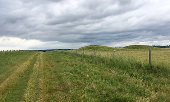
At the end of the field go over the stile back on to the road. Turn left. On your right, you will see some entrance gates beyond which is a large mansion. This is Lake House, home to the musician Sting. Continue down the lane towards Lake village. When you reach the bus shelter, take the turning on the left. The lane passes a few houses and then reaches open countryside. The track, which passes near to some burial mounds known as the Wilsford Group, leads to Springbottom Farm. After the farm buildings, the byway passes another cluster of tumuli on Normanton Down, where you reach the crest of the hill. From here, ahead in the distance, you catch your first glimpse of Stonehenge.


Although there are signs of activity many centuries before this date, the first stones appeared at Stonehenge around 3,000 BC. These were the 'blue stones', which were incredibly transported 150 miles from the Preseli Hills in Wales. Five hundred years later, around 80 stones were brought from the Marlborough Downs and placed upright in concentric circles. The blue stones were later rearranged and the area became the focus for human burials (there are more bronze age round barrows in the vicinity than at any other site in Britain). As the discovery of the 'Amesbury Archer' revealed, these were most likely the graves of important and wealthy individuals such as tribal leaders. The discovery of Roman artefacts indicates that the henge was still used as a ritualistic site up until the Romano-British period.
Stonehenge is aligned with the sunrise at the summer solstice and sunset at the winter solstice. Although it is mostly midsummer that is celebrated today, the aspect of the sun when viewed from The Avenue suggests that the winter solstice may have been more important. Recent research has also uncovered evidence of winter feasting at nearby Durrington Walls. Thousands of animal bones were found, analysis of which revealed that people had travelled huge distances – as far as from the north of Scotland – to get there (quite amazing when you consider the difficulties and dangers involved). What went on at these events is anyone's guess. It's tempting to think of the feasts as a kind of neolithic midwinter Glastonbury Festival, attracting people from far and wide who would eat, drink and be merry. But the likelihood is they had a deep spiritual significance. For an agrarian culture, the midwinter solstice is the time of rebirth. As well as rituals to ensure the sun's return, it may have also been a way of commemorating the dead. But it is highly unlikely we will never know for certain. Stonehenge remains one of the most enigmatic features in England's landscape. KB

Walks by County
Listed by the most traversed
county for each route
Berkshire
Buckinghamshire
Henley circular
Pr. Risborough-Wendover
Tring circular
Tring-Leighton Buzzard
Cambridgeshire
Cambridge-Trumpington
Whittlesford-Wandlebury
Derbyshire
Edale-Hope
Dorset
Corfe Castle-W. Matravers
East Sussex
Ashdown Forest
Berwick circular
Berwick-Seaford
Cuckmere Haven-E'bourne
Forest Row-Eridge
Glynde-Berwick
Glynde-Seven Sisters
Isfield-Lewes
Lewes circular 1
Lewes circular 2
Lewes-Hassocks
Lewes-Rottingdean
Plumpton-Hassocks
Rye-Three Oaks
Gloucestershire
Kingham circular
Toddington-Cleeve Hill
Hertfordshire
Codicote-St Albans
Odsey-Royston
Kent
Oxfordshire
Surrey
West Sussex
Bramber-Amberley
Steyning circular
West Yorkshire
Haworth-Hebden Bridge
Wiltshire
Avebury circular