

Full-day country walks in
SE England and beyond
Steyning circular via Cissbury and Chanctonbury
Distance: 11.2 miles.
Time without long breaks: 6 hours.
Terrain: One steep but gradual climb.
How to get there and back: Train to Shoreham-on-Sea, No 2 bus to Steyning. Catch the same bus back to Shoreham.
Pub breaks: There are no places to eat or drink during the course of the walk so pack supplies (or stock up in Shoreham), but Steyning at the end has the Star Inn and the White Horse, while Shoreham has a great music and real ale pub, the Duke of Wellington.
More information: You will need to coordinate bus and train times. The No 2 from Shoreham runs hourly (check here for times). The bus stop is six mins walk from the station. There is a taxi rank in case you miss it. The return bus goes directly to the station. Quite a lot of this walk is along chalky, stony tracks so walking boots are recommended.

Click on the image below to access the full map on plotaroute

Beginning and ending in the old town of Steyning, the highlights of this circular downland walk are the iconic prehistoric hill forts at Cissbury and Chanctonbury, both rich in local legend and folklore. There are some stunning views along the way, across the ridges of the Downs and to the Weald below. This is an all-seasons walk that is particularly atmospheric in winter.
For an alternative starting point which includes historic Bramber and its castle, rather than alighting at Steyning, get off the bus three stops earlier at St Mary's House and follow the route for the first section of walk 31 to the turning for Sopers Lane.
Exit Shoreham-by-Sea station and turn left onto Brunswick Road. After 150m, take a right into St Mary's Road to reach the parish church. Cut diagonally across the churchyard into Church Street and then head south until you reach the main road and the Adur estuary. Cross over to the bus stop. From here, you can catch a No 2 to Steyning. The journey takes about 20 mins. Get off at the Clock Tower. You can also explore the town at the end of the walk, but we suggest heading down the High Street and turning left into Church Street. This road has some of Steyning's oldest houses and also a small museum (there used to be a pub along here, the Norfolk Arms, but it has sadly closed).

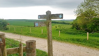
You are now on the Monarch's Way long-distance footpath. About half a mile along the lane you reach Upper Maudlyn Farm. Walk through the farmyard, passing barns and then a house on your right. Then join the concrete track that winds up the steep slope of Steyning Bowl. Although the ascent is quite arduous, there are some fantastic views when you reach the top. Turn right when you meet the road at the brow and follow the path that runs parallel to it. Cross over when you get to the wooden sign, go through the gap in the hedge and turn left, leaving the Monarch's Way and the South Downs Way to head downhill to Lychpole Bottom.

Cissbury was first used as a place of settlement more than 6,000 years ago. As well as its deployment as an Iron Age and Roman hill fort, there are Bronze Age burials here and evidence of neolithic earthworks and flint mines. There are a number of myths and legends associated with the ring. A tunnel containing buried treasure guarded by serpents is said to lead from the fort to Offington Hall at Salvington. Coins thought to be from a Saxon mint on the site carry the name 'Sithe', the Irish name for faerie. Faeries are alleged to dance at the ring on Midsummer's Eve, leading to speculation that 'Cissbury' was derived from 'Sithebury'.
On leaving Chanctonbury, head back the way you came but ignore the turning for Cissbury and carry on along the South Downs Way. About 1km from the turning you will come to a wooden signpost that indicates a bridleway on the left leading to Steyning. Take this path, which runs between fences and then turns sharp right along the top of an embankment flanked by trees with views of the Weald beyond. After about 400m, a path veers off and up to the right but keep along the main track, which heads down through the woods. Another bridleway merges from the right by a wooden signpost but keep going straight ahead.


Opposite the church there is a statue of St Cuthbert (who, according to local lore, stopped off here while transporting his mother in a wheelbarrow). Walk past the green on your right, then take the footpath that runs alongside it. When this emerges at Jarvis Lane, turn right to return to the main street. Take a left and after 400m turn right into Maudlin Lane. After passing the turning for Maudlyn Park on the right, the pavement rises above the lane. When this ends, take a right into Sopers Lane (this is where you join the route if you started the walk in Bramber). It soon becomes a country byway with the vista of the Downs on your left.

Carry on along the broad track for about a mile, passing a shaw on the left, until you reach a crossroads of tracks by some gates with signposts. Turn right here and proceed along the farm track, passing a dewpond on your right with woods rising on the escarpment to your left. After just under a mile, you will come to a farm outbuilding on the left and a gate with a National Trust sign for Cissbury Ring. You can enter it from here – proceed along the path and then turn right to walk up to the fort, described on the National Trust site as 'the most historic hill on the South Downs'.

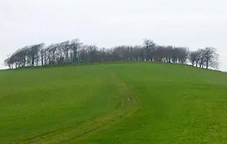
Leave Cissbury via the main exit (to the left of where you came in), then cross over the lane you were on before and walk through the car park opposite. Carry on along this path, heading north and gradually uphill, and ignoring any turnings off. Towards the end of this 3km track you will see Chanctonbury Ring and its clump of beech trees on your left. When you reach the meeting point with the South Downs Way, which crosses from left to right by a signpost, turn left to reach the ring. The climb up is a beautiful section of the walk, with superb views. Chanctonbury was the site of a prehistoric hill fort and later used as a Romano-British temple. See the panel below for more on this famous Sussex landmark and its many associations with folklore and ritual.
After 300m, past an information board for mountain bikers, go through a wooden gate on the right alongside a metal farm gate. The paths here are not marked as footpaths on the OS map, but the area – formerly the site of a rifle range – is open access land. Follow the path around to the left, as it runs alongside the trees. It swings right and heads downhill towards the valley bottom and another info board. When you reach the bottom, turn left and go through the gate. Proceed though this field and take the gate into the next. The path becomes a cinder track. Continue to the end and then take a right into Mouse Lane. At the end of Mouse Lane, turn right again to reach Steyning High Street and the Star Inn.

The circular fort at Chanctonbury is thought to date from the late bronze age. Its original usage is unknown, but it has long been linked to religious and ritualistic activity (it contains the remains of a Romano-British temple and a pentangle-shaped altar of much more recent origin was once discovered here). The clump was planted in the 18th century and although many trees were destroyed in the great storm of 1987, it is still a striking landmark. According to Sussex lore, the ring was created by the Devil and he can be summoned by running anti-clockwise around the trees seven times on a moonless night. He will offer you a bowl of soup in exchange for your soul. The site has been associated with ghosts and, like Cissbury, seems to be a focus for alleged UFO activity. In his book The Old Ways, Robert MacFarlane describes a terrifying experience when camping here, being awoken in the middle of the night by ungodly screaming. Other visitors to the ring have experienced a strange 'levitating force'.
In 1930, a Dr Goss of Steyning wrote: 'Even on bright summer days there is an uncanny sense of some unseen presence which seems to follow you about. If you enter the dark wood you are conscious of something behind you. When you stop, it stops; when you go on, it follows.' The site was celebrated in a 2019 prose and poetry album by Justin Hopper and Sharron Kraus called Chanctonbury Rings. In 2022, the pair collaborated again on Swift Wings, poems by Victor Neuberg set to music. Neuberg lived in Steyning, where he established a printing press, the Vine Press. An early publisher of Dylan Thomas's work, he is best known, however, for his corrosive relationship with Aleister Crowley. Neuberg was drawn to Chanctonbury and wrote poems about the spot, including one involving a druidic sacrifice. Both he and his erstwhile lover regarded the ring as 'a place of power'.

Justin Hopper has also written a book about Victor Neuberg called Obsolete Spells, published by Mark Pilkington's Strange Attractor press, which includes a collection of Neuberg's poems and other writings. KB
Walks by County
Listed by the most traversed
county for each route
Berkshire
Buckinghamshire
Henley circular
Pr. Risborough-Wendover
Tring circular
Tring-Leighton Buzzard
Cambridgeshire
Cambridge-Trumpington
Whittlesford-Wandlebury
Derbyshire
Edale-Hope
Dorset
Corfe Castle-W. Matravers
East Sussex
Ashdown Forest
Berwick circular
Berwick-Seaford
Cuckmere Haven-E'bourne
Forest Row-Eridge
Glynde-Berwick
Glynde-Seven Sisters
Isfield-Lewes
Lewes circular 1
Lewes circular 2
Lewes-Hassocks
Lewes-Rottingdean
Plumpton-Hassocks
Rye-Three Oaks
Gloucestershire
Kingham circular
Toddington-Cleeve Hill
Hertfordshire
Codicote-St Albans
Odsey-Royston
Kent
Oxfordshire
Surrey
West Sussex
Bramber-Amberley
Steyning circular
West Yorkshire
Haworth-Hebden Bridge
Wiltshire
Avebury circular