

Full-day country walks in
SE England and beyond
Toddington to Cleeve Hill
Click on the image below to access
the full map on plotaroute
Distance: 12.7 miles.
Time without long breaks: 6 1/2 – 7 hours.
Terrain: Some fairly steep climbs up Salter's Hill and to Belas Knap.
How to get there and back: Train to Cheltenham Spa and taxi or bus to Cheltenham Racecourse Station (see below). Then catch the Gloucestershire and Warwickshire Railway to Toddington. Return by catching the W bus from Cleeve Hill back to Cheltenham and then train.
Pubs: There are three pubs in Winchcombe and it ends at the Rising Sun in Cleeve Hill. If you have time to kill before your train from Cheltenham, the excellent Deya brewery taproom is very close to the station.
More information: It is possible to do this as a day trip from London but set off early enough to catch the first heritage train from Cheltenham Racecourse (check here for times). The quickest and easiest way to get to the racecourse station is to jump in a taxi from the rank outside Cheltenham Spa. Alternatively, catch a D or E bus to the Racecourse Park and Ride and walk round the internal road on the racecourse (about 1/2 mile). The last bus back from the Rising Sun is about 6.45pm (Mon-Sat), but you can order a cab from the pub. Trains from Cheltenham Spa to London run until about 9pm (later on Saturdays).


This is a brilliant day out in the Cotswold Hills, combining a heritage railway and visits to the ruins of a 13th century abbey, the grounds of a grand castle, a holy well and a Neolithic long barrow (see panel below). It also takes you to Winchcombe, one of the Cotswolds' most picturesque towns. There are some great views along the way, particularly from the top of Cleeve Hill. Winchcombe is almost halfway and has several pubs, so is a good place to stop for lunch dependent on your timings.
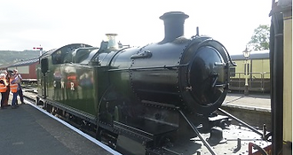
Board the train at Cheltenham Racecourse station, located next to one of the most scenic racecourses in the country, the home of the King George V Gold Cup. The original railway line used to connect Cheltenham with Birmingham via Stratford-upon-Avon. It was poorly used, however and was closed in 1976 following damage to the track. A section of the current restored line was initially reopened in 1984 and there are plans to further extend it from its current terminus at Broadway to Honeybourne. Trains run from March to December, with the Cheltenham Racecourse to Toddington stretch taking about 40 minutes.
The path goes through a series of metal swing gates and over a bridge before emerging at a lane opposite an old cottage. Turn left into the village of Didbrook and follow the lane round until you reach a junction with a tree at the centre. Turn right here and where the road swings right you will see a gate on your left (you may need to climb over it to get on to the footpath). Head diagonally across the field until you reach a ditch and then cross over the stile (it can be muddy here). Then turn right to join the Winchcombe Way. The track runs along the edge of a long field.
Hailes was a Cistercian abbey established in 1246 by Richard of Cornwall. It was rebuilt on a grand scale after it became a pilgrimage site thanks to a relic said to be a phial of holy blood. The abbey was dissolved by Henry VIII and became a private residence. From the abbey entrance, head back the way you came. Opposite the church, you will see a sign for the Cotswold Way. Go through the gate and head diagonally across the field, aiming for a wooden gate that leads on to a track by some houses. This emerges at Salter's Lane, an old trading route formerly known as Salt Way that was used for transporting (you guessed it) salt.

Go through a gap in the hedge with a gate, beyond which is a track. You will come to a wooden fence on your left. Go through the gate to reach the well-head of St Kenhelm's Well, a place of pilgrimage since the 9th century. There used to be a medieval chapel here but it was knocked down and replaced by the current building in Victorian times, using stones retrieved from the ruins. There is a plaque inside bearing the legend 'Oh traveller stay thy weary feet, drink of this water pure and sweet'. This is indeed a lovely evocative spot to sit and rest before continuing the walk (you can read more about the legend of St Kenelm and the well here).

The castle dates from the 15th century and was visited by Henry VIII and Ann Boleyn. Its church is the resting place of Katherine Parr, Henry's final wife. Elizabeth I held a three-day party here to celebrate the defeat of the Spanish Armada. The castle is open to the public, but you'd need a few hours to look around. Follow the track across the field, with the church and castle to your right. Go past a small car park next to the main castle building and then proceed straight ahead into a field with a large oak tree. Passing a children's play area on your right, go through a gate to reach the castle driveway. Turn left and walk down towards the stone bridge. Just before you reach it, turn right and head up towards a gap in the bushes, passing a bench on your right.

On the left you will come to the castle gatehouse. Take a right at the bend here along a path that cuts across a field to join the Cotswold Way by a metal gate. Follow the track until it emerges at a lane. Turn left. After 400m, turn off right by the sign and proceed up a long driveway, passing a cricket pitch on your right. Then, still on the Cotswold Way, turn off left into open fields by a wooden signpost. With great views behind you, walk up the hill towards the trees. You come to a wooden gate. Go through this and follow the railings and cross over the lane, following the path set back from the road. When you reach the gate back to the road on your left, turn right and proceed through the wood up the hill.
Leave Belas Knap on the opposite side to where you came in, crossing a stile in a gap in the wall and following the furrowed track straight ahead, with small trees and a low wall to the right. The path emerges at a farm track. Turn left. After about 500m, there is a sign for the Cotswold Way on the right. Ignore this and carry on along the mud track. A little further on, the track turns a bend and reaches a disused farm, with a derelict barn on your right. Take a right turn here, following the sign for the Winchcombe Way to head uphill. The path runs alongside a field. You can see some radio masts ahead, which is where you are heading. Go through a gate onto Cleeve Common.

Carry on along the track following the Cotswold Way, which takes you up and over the rugged banks of Cleeve Cloud iron age hill fort. There are spectacular views to your left towards the Malvern Hills. Passing a number of benches and marker posts, about 500m after the fort the Cotswold Way bears right away from the escarpment, towards the brow of the summit of Cleeve Hill (look for a wooden post just past a bench indicating the direction). It cuts across the golf course (watch out for flying golf balls), dipping down a short slope and going over some chalk steps before rising again on the other side to reach a triangulation point and a toposcope, displaying the landmarks you can see from the summit.


Toddington station is a bit of a train geek's paradise. As well as vintage steam trains (there are tours of the loco sheds on certain days), it is also home to a working narrow-gauge railway (details here). There's also the usual tourist facilities, such as a cafe. To start the walk, head out of the access road and then turn right over the bridge. Just past the houses on the right, you will see a green footpath sign by a fence. Go through the gate and take this path which takes you through fields and back down alongside the railway sidings, allowing you to view some of the old rolling stock.

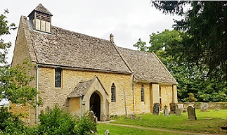
Ahead of you will see a small stone building, which is Hailes Church. At the bottom of the field, follow the track round to the right. It swings left to join a lane. Turn left and follow the lane round the bend. When you reach the road junction, turn left following the English Heritage sign to Hailes Abbey. Before you reach the abbey, you will come to the church on the left, which predates it by a century and contains some 12th-century wall paintings, including a large figure of St Christopher. Cross the road to the abbey (if you don't think you'll have time to explore the ruins or don't want to pay, you can still see some if from the next section of footpath).

Turn left and follow this quiet lane up the steep incline of Salter's Hill, with some earthworks to your right. There are expansive views behind you. After passing a drive to a farm on your left and a house on your right, a bridleway crosses the lane. About 400m further on, at the brow of the hill, turn right at the signpost along a track with a low stone wall on its left-hand side. You are now back on the Winchcombe Way. When you reach the corner of the field, go through the metal gate and follow the track down to the bottom of the fence. The Winchcombe Way turns off right here via another gate. Instead, go straight ahead, downhill across the field, aiming for the small stone building in the distance.

Carry on along the track, through a gate and past a house. The small building you can see next to it is an old chapel. Turn right when the track meets the road and when you reach some farm buildings, turn left, following the sign to Sudeley Lodge. After 350m, opposite some cottages, you will see a sign for Warden's Way and a black gate. Take the path to the end of the field, then go through a gate and over a bridge and turn right. Follow the path around the edge of this next field, turning left at the corner and following the fence. Go through the gate at the end of the field and then turn immediately right through another gate and over a bridge into Home Parks, in the grounds of Sudeley Castle.

Proceed through a metal gate and follow the path with trees to your left. It becomes a track and emerges via a gate and some steps at Castle Street on the edge of Winchcombe. Turn left to reach the town centre. There are several pubs here, including the Lion Inn on North Street. On the High Street you will find Dent's Terrace, a row of almshouses and, on the other side of the road, the church, which is famous for its 40 gargoyles or, more accurately, 'grotesques', depicting demonic creatures. Beyond the church, there are some old weavers' cottages. Just past these is our pick of the pubs, the Corner Cupboard. Leave Winchcombe by heading down Vineyard Street, almost opposite the church.

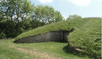
This is another fairly steep climb. When you exit the trees through a gate, turn left and follow the path as it skirts round the field, turning the corner to head uphill alongside a fence and stone wall. Go through the gate at the top of the field. The path bears left and then passes through some bushes and trees to reach Belas Knapp – a superb example of a Neolithic chambered long barrow. You can enter the burial chambers, where excavations discovered the remains of many human skeletons. This place has a distinctly wild and atmospheric feel and it's worth taking some time out here to appreciate the ambience before the final leg of the walk to Cleeve Hill. See the panel below for more on Belas Knap.

Head up the path straight ahead. You will soon pass a post on the left. At the next post, when you are almost level with the radio masts, take the track that heads towards them, passing a pond on your left. Aim for the far corner of the masts compound. Then turn right along the path that runs parallel to the wall, passing a copse on your left with views of Cheltenham below. About 300m on, the path joins the Costwold Way, which merges from the left. Just beyond where the tracks merge there is a wooden marker post. Keep along the track. You will see two trees ahead at the top of the escarpment, known as The Twins (below the trees, at the foot of the cliff, is a rocky slab known as Huddlestone's Table, which has links to Kenulf, the Saxon King of Mercia).

Turn left and head downhill from the toposcope, passing the back of a bench to your left. Keep on the grass track straight ahead, ignoring the sign on your right for the Cotswold Way. You cross a narrow chalky track. Then shortly after you come to a broader sunken chalk track, with the banks of an earthwork with a bench on top ahead of you. Turn right down this track and follow it around to the left between the banks. Continuing downhill as it becomes a grassy track, you pass a small copse on your left. Ahead of you, you will see a lane with what looks like a short castellated church tower. The Rising Sun pub is at the bottom of this lane, with the bus stop directly outside on the main road to the right.
There is some dispute over the derivation of the name Belas Knap – it either means 'beautiful hill' or 'beacon mound' (knap being an old word for a hilltop or other promontory). Although its name is medieval, it is thought to have been constructed around 5,000 years ago. Burials took place at the site over an extended period, although the burial chambers were all later blocked off. The barrow is about 200 feet long. Its shape is similar to other prehistoric mounds in this part of the country and it is thought to be the best example of the 'Cotswold-Severn' type. What appears to be the main entrance is actually a false one. As with the false entrances in the pyramids, this was possibly to deter thieves, although there is a theory it may have been intended as a 'spirit door', its usage restricted to metaphysical beings.


When the four burial chambers were excavated in the 19th century, animal bones and pottery dating from the late Neolithic period were discovered, together with the remains of 31 skeletons (interestingly, the southern chamber contained just one burial). The bones of five children and an adult male skull were also discovered by the false entrance. Archaeologists additionally found a circle of stones in the centre of the barrow, surrounding piles of ash, indicating they were once used for people to sit around a fire. Mysteriously, no trace of the stones remained when the site was excavated again in the 1920s. Julian Cope in The Modern Antiquarian (see panel on walk 51) focuses on the womanly-shape of the mound, with the false portal representing the vagina, perhaps signifying the belly of the barrow as a place of rebirth. The site is still used today as a place of pagan ritual. KB
Walks by County
Listed by the most traversed
county for each route
Berkshire
Buckinghamshire
Henley circular
Pr. Risborough-Wendover
Tring circular
Tring-Leighton Buzzard
Cambridgeshire
Cambridge-Trumpington
Whittlesford-Wandlebury
Derbyshire
Edale-Hope
Dorset
Corfe Castle-W. Matravers
East Sussex
Ashdown Forest
Berwick circular
Berwick-Seaford
Cuckmere Haven-E'bourne
Forest Row-Eridge
Glynde-Berwick
Glynde-Seven Sisters
Isfield-Lewes
Lewes circular 1
Lewes circular 2
Lewes-Hassocks
Lewes-Rottingdean
Plumpton-Hassocks
Rye-Three Oaks
Gloucestershire
Kingham circular
Toddington-Cleeve Hill
Hertfordshire
Codicote-St Albans
Odsey-Royston
Kent
Oxfordshire
Surrey
West Sussex
Bramber-Amberley
Steyning circular
West Yorkshire
Haworth-Hebden Bridge
Wiltshire
Avebury circular