

Full-day country walks in
SE England and beyond
Tring to Leighton Buzzard
Click on the image below to access
the full map on plotaroute
Distance: 12.3 miles.
Time without long breaks: 6 1/2 hours walking, but add time for pubs.
Terrain: Easy.
How to get there and back: Tring and Leighton Buzzard are on the same line, so buy a return ticket to Leighton, but alight two stops before at Tring to start the walk. The journey takes about 40 mins from London Euston.
Pubs: There are pubs a-plenty, including the Grand Junction at Bulbourne, the Angler's Rest and Red Lion at Marsworth and the Grove Lock Inn, which is right on the canal. Our favourite, the Carpenters Arms at Slapton, has now closed. The Red Lion is our pick in Leighton.
More information: For a shorter walk (10.3 miles), you can end at the Grove Tavern and then order a cab to take you to Leighton Buzzard.


This easy-to-navigate walk takes you 12 miles along the route of the Grand Union Canal, cutting through scenic Home Counties countryside, past brightly painted barges and lock keepers' cottages. There are five pubs on the way, so no chance of getting thirsty. There is a short diversion to a nature reserve and ecology centre (look out for the mammoth ankles). You also pass near the site of the Great Train Robbery, if you want to trace the footsteps of Ronnie Biggs and Co (see panel).
Exit Tring Station on the Platform 1 side and take a left along Station Road. After 300km, turn right following the sign by the bridge and go down the steps to reach the towpath of the Grand Union Canal. The canal is the principal waterway linking London to the Midlands. After about 15 minutes' walk along the towpath, it rises to meet Marshcroft Lane by a bridge. Cross over the lane and take the footpath opposite (not the towpath, which continues along the other side of the canal). After about 500m, follow the path as it turns right away from the canal and runs between trees.
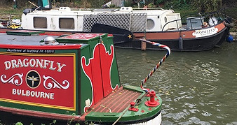
On leaving College Lake, take the path that runs parallel to the road you previously walked down. This comes out at a bridleway. Turn left to reach the road and then right. A few yards down the road you will cross a bridge over the canal and arrive at the Grand Junction pub. You can access the towpath from the beer garden. Passing an ironworks gallery on the other side, you come to a lovely section of the canal which runs between a series of locks. After crossing a bridge over the Wendover Arm, you come to Marsworh Top Lock, with its toll house and some canal works on the other side. Continue along the towpath, passing two white lock keepers' cottages. After the second house, the path runs alongside two reservoirs.

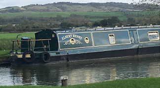
Return to the canal the way you came, going through the railings and down the slope, turning left and going under the bridge. Continue along the towpath, with fields on the other side. After half a mile you pass a lock keeper's cottage and a further half a mile on you come to the boat moorings at Cook's Wharf. Go under the road bridge to reach Pitstone Marina and then continue under the railway bridge. Shortly beyond this, you will pass a swing bridge. Carry on past Seabrook Locks, and another lock keeper's cottage with views towards Ivinghoe Beacon to your right (see walk 9).

Although there isn't really a lot to see, for anyone interested there's a diversion of about a mile you can make here to the scene of the Great Train Robbery. Walk up the slope to the bridge and then along the path that runs parallel to the towpath. The path soon turns left along the edge of a field. Cross over the road, turn right and then take a left to reach Bridego Bridge, where, in 1963, a gang of robbers looted sacks of money worth millions from a mail train (see panel below). Return back to the canal the way you came.

Cross back over the lock to continue on the path. going under a busy road and then passing some boat works on the other side of the canal. About half a mile on, you pass under a bridge carrying a cycleway. You then come to a white footbridge. If you intend to continue into Leighton Buzzard town centre (about 15 mins walk from the station), continue on the towpath for another 500m until you reach the bridge over Leighton Road. Climb up the slope and turn right, crossing the bridge, and then turn right into Bridge Street. The town has some nice historic parts. In terms of pubs, we recommend the friendly and quirky Red Lion in North Street.


The path comes out a junction of farm tracks. Take the track opposite which continues in the same direction. It becomes a path which leads into a field which lies alongside the railway line. Turn left, following the grassy path as it runs parallel to the tracks. You emerge via some wooden railings at a road by a bridge. Turn left and walk down the road (Upper Ickneild Way), being careful of the traffic. After about 250m you will come to the entrance to College Lake Nature Reserve. The 70-hectare site is home to over 1,000 different species of wildlife and is one of the best places in the region to spot water birds. The visitor eco-centre contains wildlife and geology displays as well as a cafe.

The canal goes around a hairpin bend. You will come to the Water's Edge, an upmarket pub/restaurant (if you fancy a more cosy pub, cut through the car park to the side to reach the road, turning left for the Angler's Rest). From the road bridge over the canal, continue along the towpath but this time on the right-hand bank (on the other side to the derelict White Lion Inn). In 400m, you come to another road bridge. Turn left over the bridge and then continue along the opposite side of the canal. You will see a church on your right and after 500m you reach another bridge. Walk up the slope to the road and turn right to cross over to reach the village of Marsworth and the Red Lion pub.
When you reach a bridge, go under it rather than walk up to the road. Carry on along the next stretch, past Ivinghoe Top Lock to reach the white cottages at Horton Wharf Farm and Horton Lock. Just under half a mile further on, you will come to a road bridge. Continue along the towpath (when we originally did this walk in 2017 we turned off here to go to a lovely pub, the Carpenter's Arms in Slapton. Unfortunately, it has long since closed). The next section, past Slapton Lock, runs through open countryside. If it's the right season, you'll find sloe berries for making sloe gin in the hedgerows here. Continue on the towpath for just over half a mile until you reach a small footbridge.

After about a mile along the narrow towpath you will come to Church Lock at Grove, next to which is the former church of St Michael's. Cross over the bridge here to continue along the path on the other side of the canal. Half a mile further on you come to the moorings of Grove Lock Marina. Cross over the lock to reach the Grove Lock pub, adjacent to the canal. When we first did this walk, we ended it here and then called a cab to take us to Leighton Buzzard. So if you fancy a shorter version of the walk, you can end it here. To continue to the town or the station, it's about two miles.

If heading directly to the station (which is actually in Linslade), cross over the white footbridge and follow the path round, passing houses on your left to reach a park and sports field. Follow the path past the tennis club and bowling green to reach Mentmore Road. Turn right and walk up to the road junction. Carry on straight ahead and then take the first left into Church Road. At the junction with Vicarage Road, rather than following Church Road round the corner, take the lane ahead that bears left and runs past the church. Then cut across the recreation ground to reach the station.
Although this walk takes you along a section of the Grand Union Canal (constructed between 1793 and 1805 as the Grand Junction Canal), the most famous, or rather infamous, incident connected with these parts concerns the form of transport that ensured the demise of the canal network. At around 3am on Thursday, 8 August 1963, at Bridego railway bridge near Mentmore, a gang of 16 men, led by Bruce Reynolds, escaped with £2.6m (about £50m in today’s money) from a mail train. The operation was meticulously planned. The men tampered with a signal, switching it from green to red at Sears Crossing, half a mile north of the bridge. They then uncoupled the carriage containing the valuable loot and forced the train driver, Jack Mills, to move the train to the bridge (its location marked out with sheets across the tracks), where the getaway vehicles were waiting. They unloaded the sacks and then drove almost 30 miles to their hideout at Leatherslade Farm.


The gang had intended to stay at the farm until the Sunday, but believed the police were on their tail so left the following day. They instructed a collaborator to torch the farm to destroy any evidence, but he failed to do so. It was this omission that led to their capture, as the police discovered fingerprints on a Monopoly board inside the farmhouse. Some of the robbers, such as Ronnie Biggs and Buster Edwards, who were members of the London criminal underworld, have since achieved a kind of anti-hero status in popular culture, but it is often forgotten that Jack Mills was seriously injured by the gang, suffered trauma as a result of the event and was unable to work for many years. If you do make the short detour to the bridge, you won't find anything to mark what happened there. It feels strange that this mundane spot was once the centre of an incident that would dominate the news headlines for months and became forever impregnated on the national consciousness. KB
Walks by County
Listed by the most traversed
county for each route
Berkshire
Buckinghamshire
Henley circular
Pr. Risborough-Wendover
Tring circular
Tring-Leighton Buzzard
Cambridgeshire
Cambridge-Trumpington
Whittlesford-Wandlebury
Derbyshire
Edale-Hope
Dorset
Corfe Castle-W. Matravers
East Sussex
Ashdown Forest
Berwick circular
Berwick-Seaford
Cuckmere Haven-E'bourne
Forest Row-Eridge
Glynde-Berwick
Glynde-Seven Sisters
Isfield-Lewes
Lewes circular 1
Lewes circular 2
Lewes-Hassocks
Lewes-Rottingdean
Plumpton-Hassocks
Rye-Three Oaks
Gloucestershire
Kingham circular
Toddington-Cleeve Hill
Hertfordshire
Codicote-St Albans
Odsey-Royston
Kent
Oxfordshire
Surrey
West Sussex
Bramber-Amberley
Steyning circular
West Yorkshire
Haworth-Hebden Bridge
Wiltshire
Avebury circular